Bab El Kantra Bridge جسر باب القنطرة | |
|---|---|
 | |
| Coordinates | 36°22′8.30″N 6°37′5.40″E / 36.3689722°N 6.6181667°E |
| Carries | Motor vehicles, Pedestrians |
| Crosses | Gorge valley of the Rhumel River |
| Locale | Constantine, Algeria |
| Other name(s) | جسر القنطرة |
| Characteristics | |
| Design | 1792–1857: Aqueduct bridge
|
| Material | Reinforced concrete |
| Total length | 128 m |
| Width | 14 m |
| Longest span | 57.4 m (188 ft) [1] |
| No. of spans | 4 |
| Clearance below | 125 m (410 ft) [2] |
| History | |
| Inaugurated | 1792 |
| Rebuilt | 1952 |
| Collapsed | 1857 |
| Replaces | 1952 |
| Statistics | |
| Toll | Free |
| Location | |
Bab El Kantra Bridge is one of eight famous high-level bridges that cross the Rhumel River gorge in Constantine, Algeria. The Kantara bridge is the oldest and has taken several different forms over the years: from a 1792 Ottoman-style multi-arch bridge, to an 1863 French iron arch, to its current form as a concrete arch bridge. Like the higher Sidi M'Cid Bridge, there is a unique, natural "bridge" almost directly under the span that blocks much of the river from view. Partial remains of the earlier stone bridges can still be seen on top of this natural bridge.
History
El Kantara "الكنترة" word comes from Latin "Centuriation" (Derja: meaning a bridge) [3] was Constantine's main access route. It is the site of the main assaults on the city. In 1185 all the Roman bridges were destroyed. Only El Kantara is rehabilitated. In 1304 it was destroyed again.
Between 1771 and 1792 Salah Bey, one of the most famous rulers of the city, promoted a good number of urbanization works and mosques. He entrusted the reconstruction of the Roman bridge to the Balearic builder Bartolomeo. To carry it out, he started from the foundations and ruins of the ancient bridge, and completed it with stone from the ruins of the ancient Roman amphitheater. The bridge roughly reproduces the configuration of the Roman original. The new reconstruction reduces the number of arches, solidifies the arches of the intermediate level and also re-establishes the siphon that supplies the city from Djebel Ouahch.
The Ottoman reconstruction is described in the 1853 testimony of Charboneau:
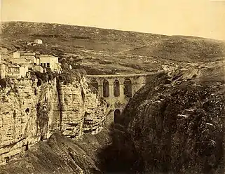
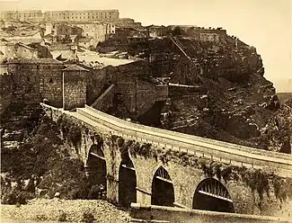
The construction, as we see it today, was erected in 1788 and 1789 under the principality of Salah Bey by a Balearic engineer. It has two levels. The lower level is made up of two arches; one of them, close to the city, was solidified at an unknown time. The two arches are supported by three piers whose structure is obviously Roman, from the base to the cornice. On the second level, which rises 16 meters above the lower floor, it is made up of four arches. The two central ones lean on the lower arches; its vaults are pointed, while the sides are circular vaults and visibly larger. The height of the bridge reaches 65 meters; the board is 60 meters long.
Thus, the similarities between the description and the documentary images of the mid-19th century are evidenced: those taken in 1856 by John Beasley Greene, a photographer and archaeologist known for his travels to Egypt and the East.
 Bab El kantara Bridge 1792-1857
 Side view of the Bridge in Ottoman era
- In 1836, during the first French attack against the city which is known as the Battle of Constantine, General Camille Alphonse Trézel's troops attempted to blow up the door which closed the bridge. The assault is repulsed and many soldiers are rushed into the gorges.
- On March 18, 1857, the bridge collapsed after the passage of an invading French infantry detachment. The aqueduct is also washed away in the landslide and the city's main source of water was cut off.
- In 1863 and after three years of work and remodelled at the beginning of the 20th century. The district near the bridge is called Bab El Kantara in Arabic, which means 'the bridge door', because the bridge was indeed closed by a door. The elements of this door still exist and are stored on solid ground along the road to the Corniche.
- In 1951, part of the cast iron cladding of the metal arch having collapsed, the municipality took the opportunity to undertake major works and widen both the walkways and the roadway.
- In 1952 the actual bridge was inaugurated ended at a monumental gate with two stone arches that defended the entrance to the city. The two arches of this gate were very narrow and considerably hampered traffic.
See also
References
- ↑ Sakowski (16 October 2009). "El Kantara Bridge". highestbridges.com. Constantine, Algeria: highestbridges. Retrieved December 7, 2021.
- ↑ Janberg, Nicolas (15 September 2009). "Pont d'El Kantara". structurae.net. Constantine, Algeria: structurae. Retrieved December 7, 2021.
- ↑ "صول الزراعة في بلاد المغرب القديم" (PDF).
External links
- Images of el-Kantara in Manar al-Athar digital image archive