Bad Gams | |
|---|---|
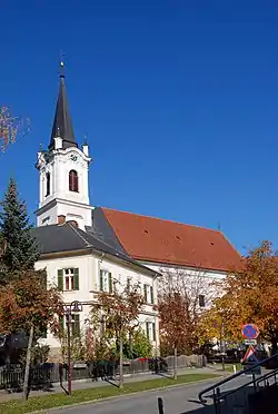
 Bad Gams parish church | |
 Coat of arms | |
 Bad Gams Location within Austria | |
| Coordinates: 46°52′12″N 15°13′24″E / 46.87000°N 15.22333°E | |
| Country | Austria |
| State | Styria |
| District | Deutschlandsberg |
| Government | |
| • Mayor | Peter Senekowitsch (SPÖ) |
| Area | |
| • Total | 48.71 km2 (18.81 sq mi) |
| Elevation | 430 m (1,410 ft) |
| Population (1 January 2016)[1] | |
| • Total | 2,306 |
| • Density | 47/km2 (120/sq mi) |
| Time zone | UTC+1 (CET) |
| • Summer (DST) | UTC+2 (CEST) |
| Postal code | 8524 |
| Area code | 03463 |
| Vehicle registration | DL |
| Website | www.bad-gams.steiermark.at |
Bad Gams (ⓘ) is a former municipality and, traditionally, a market town, in the district of Deutschlandsberg in Styria, Austria, roughly 30 km from Graz. Since the 2015 Styria municipal structural reform, it is part of the municipality Deutschlandsberg, together with Deutschlandsberg, Freiland bei Deutschlandsberg, Kloster, Osterwitz and Trahütten.[2]
Population
| Year | Pop. | ±% |
|---|---|---|
| 1869 | 2,389 | — |
| 1880 | 2,303 | −3.6% |
| 1890 | 2,292 | −0.5% |
| 1900 | 2,294 | +0.1% |
| 1910 | 2,360 | +2.9% |
| 1923 | 2,217 | −6.1% |
| 1934 | 2,381 | +7.4% |
| 1939 | 2,262 | −5.0% |
| 1951 | 2,378 | +5.1% |
| 1961 | 2,326 | −2.2% |
| 1971 | 2,270 | −2.4% |
| 1981 | 2,218 | −2.3% |
| 1991 | 2,296 | +3.5% |
| 2001 | 2,300 | +0.2% |
| 2011 | 2,289 | −0.5% |
References
This article is issued from Wikipedia. The text is licensed under Creative Commons - Attribution - Sharealike. Additional terms may apply for the media files.