Bad Kissingen | |
|---|---|
 Flag  Coat of arms | |
| Country | Germany |
| State | Bavaria |
| Adm. region | Lower Franconia |
| Capital | Bad Kissingen |
| Government | |
| • District admin. | Thomas Bold (CSU) |
| Area | |
| • Total | 1,137 km2 (439 sq mi) |
| Population (31 December 2022)[1] | |
| • Total | 104,567 |
| • Density | 92/km2 (240/sq mi) |
| Time zone | UTC+01:00 (CET) |
| • Summer (DST) | UTC+02:00 (CEST) |
| Vehicle registration | KG, BRK, HAB |
| Website | landkreis-badkissingen.de |
Bad Kissingen is a Landkreis (district) in Bavaria, Germany. It is bounded by (from the northwest and clockwise) the district Main-Kinzig and Fulda in Hesse, and the districts of Rhön-Grabfeld, Schweinfurt and Main-Spessart.
History
The district was established in 1972 by merging the former districts of Bad Kissingen, Bad Brückenau and Hammelburg.
Geography
The district is located in the southern portion of the Rhön Mountains. The Fränkische Saale river (an affluent of the Main) enters the district in the north and leaves to the southwest.
Coat of arms
The coat of arms displays:
Towns and municipalities
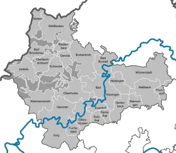
Clickable map of towns and municipalities in the district
| Towns | Municipalities | |
|---|---|---|
References
- ↑ Genesis Online-Datenbank des Bayerischen Landesamtes für Statistik Tabelle 12411-003r Fortschreibung des Bevölkerungsstandes: Gemeinden, Stichtag (Einwohnerzahlen auf Grundlage des Zensus 2011)
External links
Wikimedia Commons has media related to Landkreis Bad Kissingen.
- Official website (German)
Towns and municipalities in Bad Kissingen (district) | ||
|---|---|---|
Coat of Arms of Bad Kissingen district | ||
This article is issued from Wikipedia. The text is licensed under Creative Commons - Attribution - Sharealike. Additional terms may apply for the media files.