Bafoi
Bafwoi or Sanai Bafai, Bafai Gora, Bafoi Kanai | |
|---|---|
 Bafoi | |
| Coordinates: 09°52′N 08°17′E / 9.867°N 8.283°E[1] | |
| Country | |
| State | Kaduna State |
| LGA | Zangon Kataf |
| District | Kanai |
| Time zone | UTC+01:00 (WAT) |
| Climate | Aw |
Bafoi (also Bafoi Kanai, Bafai Gora)[2] is a village in Kanai district of Zangon Kataf Local Government Area in southern Kaduna state in the Middle Belt region of Nigeria. The postal code of the area is 802145.[3][4][5]

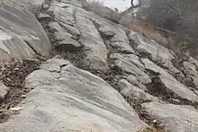
Cross section of a rocky terrain in Bafoi.
Settlements
[6] Before 2017, it used to be a district of its own. However, it was later merged with Kanai district.[7] Among the settlements in this district were:
- Ayak
- Aza Magoni
- Azambat
- Bafoi (also Sanai)
- Chen Didan
- Ma-Avwuong
- Makura
See also
References
- ↑ "Bafai, Gora, Kaduna State, Nigeria". Retrieved September 28, 2020.
- ↑ Achi, B.; Bitiyonɡ, Y. A.; Bunɡwon, A. D.; Baba, M. Y.; Jim, L. K. N.; Kazah-Toure, M.; Philips, J. E. (2019). A Short History of the Atyap. Tamaza Publishinɡ Co. Ltd., Zaria. pp. 9–245. ISBN 978-978-54678-5-7.
- ↑ "Nigeria Postcode". Retrieved September 28, 2020.
- ↑ "Bafoi, Zangon Kataf". Nigeria Postcode. Retrieved September 28, 2020.
- ↑ "Bafoi Gora". Mapanet. Retrieved September 28, 2020.
- ↑ Lere, Mohammed (June 12, 2017). "In major restructuring, El-Rufai slashes Kaduna districts to pre-2001 numbers". Premium Times. Retrieved September 28, 2020.
- ↑ Achi et al (2019) p. 11
This article is issued from Wikipedia. The text is licensed under Creative Commons - Attribution - Sharealike. Additional terms may apply for the media files.