Ballymote
Baile an Mhóta | |
|---|---|
Town | |
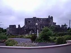
 Ballymote Castle | |
 Ballymote Location in Ireland | |
| Coordinates: 54°05′23″N 8°31′00″W / 54.0896°N 8.5167°W | |
| Country | Ireland |
| Province | Connacht |
| County | County Sligo |
| Elevation | 69 m (226 ft) |
| Population | 1,711 |
| Time zone | UTC+0 (WET) |
| • Summer (DST) | UTC-1 (IST (WEST)) |
| Eircode routing key | F56 |
| Telephone area code | +353(0)71 |
| Irish Grid Reference | G662150 |
Ballymote (Irish: Baile an Mhóta, meaning 'town of the motte/mound') is a market town in southern County Sligo, Ireland. It is around 20 km south of Sligo town in the province of Connacht, which is in the north-west of Ireland. Ballymote lies in the barony of Corran. It is a commuter town with a strong history of independent enterprises along with firm local health, school, and transport services. Ballymote is on the main Dublin to Sligo Train Line, and 10 minutes from the N4 / N17 roads. The town serves a large hinterland area in south east County Sligo.
The Norman Ballymote Castle dates from the 1300s, and the Book of Ballymote was written in or near the town in the 1390s.
History
The origins of the settlement appear to have been derived from the 12th century Norman Castle,[3] though evidence of earlier settlement and farming in area from c. 1000 BC exists through the presence of ringforts, cairns, and archaeological remains.[4][5]
Ballymote was much affected by the disruption of the full conquest of Ireland by the English and Protestant settlers in the early modern period (1536–1691). Ballymote was ravaged several times in the 16th century and finally burned to waste.[6] In 1608 King James I granted an estate encompassing the castle and area around the town to James Fullerton,[7] this was soon to pass to the Taaffes.[8] Following litigations, court action and a forced sale John Fitzmaurice (Lord Shelburne) bought the Ballymote estate in 1753.[9][lower-alpha 1]
On coming to Ballymote, Shelburne found the land mostly uncultivated with the inhabitants, all Roman Catholic, making no attempt to manufacture goods but subsisting on herding cattle.[10][12] Shelburne made a start to establish Ballymote as a centre for the linen industry in County Sligo,[13] by provisioning cottages for Protestant weavers and spinners brought in from Ulster.[10] Expansion was slow, and with Shelburne's death in 1761 his widow attempted to progress his project through managers, expanding from 20 to 60 looms.[14] In 1774 the younger son, Thomas Fitzmaurice, after studying the linen business, began the modern expansion of the town, with the construction of a bleach mill, workers houses,[4] and Earlsfield House, a residence for himself.[11] In 1776 it was noted that Fitzmaurice had invited architect James Paine to plan a redevelopment of the town with a new street layout, a market house and other associated houses. No records exist of Paine's plans, and it is not clear if his designs were implemented.[15] By 1799, it was recorded that most of the inhabitants of Ballymote were weavers. Linen production peaked in the period from 1815 to 1820, but went into steep decline by the 1840s.[16] Within the history of planned industrial settlements centred around the linen industry in Ireland, this was one of the later attempts[17] with the manufacturing of linen in the town ultimately abandoned.[18]
In 1833, the ownership of the town was transferred from the Fitzmaurices to the Gore-Booth family of Lissadell,[19] who has established a corn mill in the town in 1795.[20] In 1837, the town consisted of 140 houses on a single main street at the junction of six roads, and was owned by Robert Gore-Booth.[3] A map from 1847 shows the core layout of the current town established.[4]
Annalistic references
From the Annals of the Four Masters:
Geography
Ballymote lies 24 km south-east of Sligo Town and 193 km west from Dublin. Caves of Keash are located 5 km south of the town
Demography
In 1900 Ballymote had a population of 1,145,[21] compared to 1,711 in 2022.[2]
Economy
In addition to a selection of shops and services, there are factories just outside the town at Ballybrennan, and a small business park at Carrownanty on the R296 Road to Tobercurry.[22][23] There is a livestock mart and a microbrewery.[24][25] The wider area is mainly agricultural,[4] with many people commuting to Carrick on Shannon and Sligo town for work.[26]
Sport
A number of sports are played in the town, including Gaelic football and athletics at Corran Park and soccer at Brother Walfrid Memorial Park. The town had had a nine-hole golf course on the outskirts of the town since 1943 (though some claim 1930s), which relocated c. 1993. and which closed in 2019 as financially unviable with dwindling membership.[27][28]

Heritage and culture
The Ballymote Heritage Group was founded on 30 May 1984. At the bank holiday at the beginning of August they organise a heritage weekend with a variety of events and an annual publication, The Corran Herald.[29][30]
The Irish Raptor Research Centre near Templehouse Lough was originally set up for research purposes but since 2003 demonstrates the fun and educational Eagles Flying Show as well.[31]
A children's playground has been created at Town Park. A miniature railway has been in operation there on some summer weekends.[32]
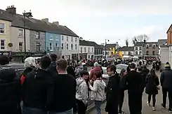
The town regularly host St Patricks day parades each year.
Landmarks
Buildings
It is a historic town, with Ballymote Castle, the last and the mightiest of the Norman castles in Connacht.[33] This castle, dating from 1300, was built by Richard de Burgh. It also has a Market House, a three-bay, two-story building formerly used by the South Sligo Adult Community Mental Health team of the Health Service Executive.
There has been a library in the town since 1949; originally run from the Loftus Hall, it was relocated to the former courthouse in 1984 before moving in 2011 to its current location on Teeling Street.[34]
Temple house is located approximately 2 km from the town.
September 11 memorial
The then Mayor of New York City, Michael Bloomberg, unveiled Ireland's national monument to the 69th Infantry Regiment (aka The Fighting 69th) and Michael Corcoran in Ballymote on 22 August 2006. At the foot of the monument is a piece of steel from the World Trade Center in New York, which was attacked on September 11, 2001. The steel was donated by the family of a local man who died in the attack.
Transport
Ballymote lies on regional roads R293, R295 and R296, and on the main Dublin to Sligo railway line. Ballymote railway station opened on 3 December 1862.[35] local link bus services are provided daily.

The town is also served by Ireland West Airport that is located approximately 30 minutes away.
People

Some well-known people from Ballymote and the surrounding areas include:
- Feldmarschall The 3rd Earl of Carlingford (1639–1704). Born in Ballymote, Lord Carlingford became the head of an old Hiberno-Norman family. He was a senior-ranking commander in the Imperial Army and the Army of the Holy Roman Empire, the armed forces of the Habsburg dynasty.[lower-alpha 2]
- Michael Corcoran, brigadier general of the 69th Infantry Regiment during the American Civil War.
- Paddy Killoran (1903–1965), one of the finest exponents of the South Sligo Style of Fiddle playing (born near Ballymote).[36]
- Sophia McColgan, recipient of the 1998 Irish Person of the Year award on behalf of her family for her courage in bringing a familial abuse story to public attention.[37]
- John Perry, a Teachta Dála and Minister of State for Small Business in the 31st Dáil.
- Eamon Scanlon, a Teachta Dála in the 32nd Dáil and a Senator in the 22nd Seanad.
- Feldmarschall Nicholas Graf von Taaffe and 6th Viscount Taaffe (1685–1769). Born in Ballymote, the Graf was a cousin of The 3rd Earl of Carlingford. He was a senior-ranking military commander in the Holy Roman Empire (also known as the Austrian Empire).
 Ireland's National Monument to Fighting 69th in Ballymote
 - James Sreenan former Chief of Staff of the Irish Defence Forces
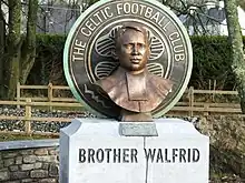
- Brother Walfrid, the founder of Glasgow Celtic Football Club.
See also

References
Notes
Footnotes
- ↑ D'Imperio 2014.
- 1 2 "Interactive Data Visualisations: Towns: Ballymote". Census 2022. Central Statistics Office. Retrieved 30 September 2023.
- 1 2 Lewis 1837b.
- 1 2 3 4 Development Planning Unit 2012, p. 3.
- ↑ Preston 1985, p. 4.
- ↑ O'Rorke 1900, p. 160.
- ↑ O'Rorke 1900, p. 161.
- ↑ O'Rorke 1900, p. 161–162.
- ↑ O'Rorke 1900, p. 166–167.
- 1 2 3 Lewis 1837m.
- 1 2 Chambers 2018, p. 13.
- ↑ Young 1887, p. 66.
- ↑ Coleman 2013, pp. 24–29.
- ↑ Young 1887, pp. 66−67.
- ↑ "Paine, James". Dictionary of Irish Architects. Retrieved 30 October 2021.
- ↑ O'Rourke, Felim (8 January 2008). "When Sligo had 3 markets - for butter, linen and corn". Irish Independent. Retrieved 30 October 2021.
- ↑ F. H. A. Aalen; Kevin Whelan; Matthew Stout (1997), Atlas of the Irish rural landscape, Toronto: University of Toronto Press, ISBN 0-8020-4294-5, OCLC 39672233
- ↑ Darley 1975, p. 149.
- ↑ Chambers 2018, pp. 13–15.
- ↑ Keaney 2010.
- ↑ "Description of County Sligo from Atlas and Cyclopedia of Ireland (1900)". Library Ireland. Archived from the original on 22 January 2011. Retrieved 24 February 2009.
- ↑ Ballymote-Tobercurry, Municipal District (28 November 2016). "Minutes of the meeting of the Municipal District of Ballymote-Tobercurry" (PDF). Sligo County Council. Retrieved 12 May 2020.
- ↑ "Ballymote Business Park could create 200 new jobs". The independent.
- ↑ "Focus on Ballymote Mart Day in our Rural Life Feature". The Sligo Champion. 29 January 2013. Retrieved 20 April 2017.
- ↑ "The White Hag Brewery". The White Hag. Retrieved 20 April 2017.
- ↑ Development Planning Unit 2012, p. 28.
- ↑ "Ballymote Golf Club". Discover Ireland. Archived from the original on 21 April 2017. Retrieved 20 April 2017.
- ↑ "Ballymote Golf Club closes down". 9 August 2019.
- ↑ "Welcome to Ballymote Heritage Sligo". Ballymote Heritage Group. Retrieved 18 April 2017.
- ↑ "The Corran Herald Previous Issues". Ballymote Heritage Group. Retrieved 18 April 2017.
- ↑ "About Us". Eagles Flying. Retrieved 20 April 2017.
- ↑ "Council urged to help get Ballymote mini-train back on track". Sligo Champion. 16 July 2016. Retrieved 15 October 2017.
- ↑ "Ballymote Castle". Irelandseye.com. Retrieved 28 May 2007.
- ↑ BHG 2011, p. 77.
- ↑ "Ballymote station" (PDF). Railscot - Irish Railways. Archived (PDF) from the original on 26 September 2007. Retrieved 7 September 2007.
- ↑ "Tour 2 - Paddy Killoran, 1904-1965 (P)". Coleman Country. Retrieved 18 April 2017.
- ↑ McKay, Susan (2004) [1998]. Sophia's Story. Gill & McMillan. ISBN 978-0717137923.
Sources
- BHG (2011). "New Community Library and Fire Station in Ballymote" (PDF). The Corran Herald. No. 44. The Ballymote Heritage Group. p. 77. Archived (PDF) from the original on 24 December 2016. Retrieved 9 May 2019.
- Chambers, Sr Nell (2018). "The rich history of Earlsfield House, Ballymote" (PDF). The Corran Herald. No. 51. Ballymote Heritage Group. pp. 13–15.
- Coleman, John (2013). "Further Light on the Linen Industry in 18th Century Ballymote" (PDF). The Corran Herald. No. 46. Ballymote Heritage Group. pp. 24–29.
- CSO (2016). "Population and Actual and Percentage Change 2011 to 2016 by Alphabetical List of Towns, CensusYear and Statistic". Central Statistics Office (Ireland). Retrieved 16 August 2017.
- Darley, Gillian (1975). Villages of vision (1st ed.). London: The Architecctural Press Ltd. ISBN 0851397050. OCLC 925311089. OL 4934366M.
Estate belonging to Gore Booth family; single street with 160 houses. Linen industry failed
- D'Imperio, Antio (2014). "Ballymote Castle". irishstones.org. Retrieved 17 May 2020.
- Development Planning Unit (September 2012). Ballymote Local Area Plan 2012–2018 (PDF) (Report). Sligo Count Council. Archived (PDF) from the original on 24 May 2019. Retrieved 12 May 2020.
- Lewis, Samuel (1837b). "Ballymote, a market and post town". Library Ireland. Retrieved 25 October 2021.
- Lewis, Samuel (1837m). "Sligo Manufacturing". Library Ireland. Retrieved 31 October 2021.
- Keaney, Harry (14 January 2010). "Plan to turn Ballymote Corn Mill into a major tourism attraction". Sligo Champion. Retrieved 3 November 2021.
- O'Rorke, Terence (1900). The History of Sligo: Town and Country. Vol. 2. Dublin: James Duffy and Co. OCLC 367563777. OL 24786532M.
- Preston, Una (25 October 1985). "Ballymote" (PDF). Corran Herald. No. 1. Ballymote Heritage Group.
- Young, Arthur (1887). A Tour in Ireland 1776–1779. Cassell & Company. OCLC 1157922244. OL 7147022M.
Further reading
- McGettrick, Tom (April 1987a). "The Linen Industry : Heritage of Other Times" (PDF). The Corran Herald. No. 9. Ballymote Heritage Group. p. 5.
- McGettrick, Tom (July 1987b). "The Linen Industry : Heritage of Other Times" (PDF). The Corran Herald. No. 10. Ballymote Heritage Group. p. 15.
- Mc Keon, John (2019). "Lord Palmerston's Ballymote Estate: A Place of Memorable Change" (PDF). The Corran Herald. No. 52. Ballymote Heritage Group. pp. 8–13.
- Ní Chinnéide, Síle (1977). "A Frenchman's Tour of Connacht in 1791. Part II". Journal of the Galway Archaeological and Historical Society. Galway Archaeological & Historical Society. 36: 30–42. JSTOR 25535500.
External links
 Ballymote travel guide from Wikivoyage
- . Encyclopædia Britannica. Vol. 3 (11th ed.). 1911.
- Ballymote Town Website
- Ballymote Parish
