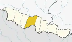
Basantapur
बसन्तपुर بست پور | |
|---|---|
 Basantapur Location in Nepal | |
| Coordinates: 26°56′0″N 85°42′0″E / 26.93333°N 85.70000°E | |
| Country | |
| Zone | Janakpur Zone |
| District | Sarlahi District |
| Population (2022) | |
| • Total | 14,283 |
| Time zone | UTC+5:45 (Nepal Time) |
| Area code | .06 |
Basantapur ( बसंतपूर) is a village in Haripurwa Municipality of Sarlahi District in Madhesh Province, Nepal. It is bordered by Fulkaha on the east, Sokanaha on the west, Shrinagar on the north and Haripurwa on the south. Which has a total area of 436/km. And which has a total population of about 14283. And there are several neighborhoods including Bagiyaba, Toka, Mirchaya, Baharwa, and Harsaha Local languages include Bajika, Maithili, Nepali and Urdu The village has three mosques and four madrasas, including two for girls, and four schools The occupation of the people there is farming. [1]
References
- ↑ "Nepal Census 2001", Nepal's Village Development Committees, Digital Himalaya, archived from the original on 12 October 2008, retrieved 15 November 2009.
External links
This article is issued from Wikipedia. The text is licensed under Creative Commons - Attribution - Sharealike. Additional terms may apply for the media files.
