Baumgartenberg | |
|---|---|
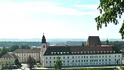 Monastery | |
 Coat of arms | |
 Baumgartenberg Location within Austria | |
| Coordinates: 48°12′32″N 14°44′39″E / 48.20889°N 14.74417°E | |
| Country | Austria |
| State | Upper Austria |
| District | Perg |
| Government | |
| • Mayor | Gerhard Fornwagner (2021) (ÖVP) |
| Area | |
| • Total | 15.73 km2 (6.07 sq mi) |
| Elevation | 237 m (778 ft) |
| Highest elevation | 240 m (790 ft) |
| Lowest elevation | 230 m (750 ft) |
| Population (2018-01-01)[2] | |
| • Total | 1,734 |
| • Density | 110/km2 (290/sq mi) |
| Time zone | UTC+1 (CET) |
| • Summer (DST) | UTC+2 (CEST) |
| Postal code | 4342 |
| Area code | 07269 |
| Vehicle registration | PE |
| Website | www.baumgartenberg.at |
Baumgartenberg is a municipality in the district Perg in the Austrian state of Upper Austria.
Geography
Baumgartenberg lies at round 237 meters. The extension is 4.5 kilometers from north to south, from west to east 6.8 kilometers. The total area is 15.7 kilometers ². 23.6% of the area is forested, 63.7% of the area ais used for agriculture.
Quarters include Amesbach, Au, Baumgartenberg, Deiming, Hehenberger, High, Kolbinger, Kühofen, Fiefs, Mettensdorf, Muhlberg, Obergassolding, Pitzing, Schneckenreit, Steindl and Untergassolding.
Population
| Year | Pop. | ±% |
|---|---|---|
| 1869 | 1,227 | — |
| 1880 | 1,336 | +8.9% |
| 1890 | 1,391 | +4.1% |
| 1900 | 1,519 | +9.2% |
| 1910 | 1,399 | −7.9% |
| 1923 | 1,385 | −1.0% |
| 1934 | 1,429 | +3.2% |
| 1939 | 1,364 | −4.5% |
| 1951 | 1,165 | −14.6% |
| 1961 | 1,121 | −3.8% |
| 1971 | 1,295 | +15.5% |
| 1981 | 1,402 | +8.3% |
| 1991 | 1,442 | +2.9% |
| 2001 | 1,399 | −3.0% |
| 2009 | 1,548 | +10.7% |
| 2015 | 1,696 | +9.6% |
| 2021 | 1,798 | +6.0% |
References
- ↑ "Dauersiedlungsraum der Gemeinden Politischen Bezirke und Bundesländer - Gebietsstand 1.1.2018". Statistics Austria. Retrieved 10 March 2019.
- ↑ "Einwohnerzahl 1.1.2018 nach Gemeinden mit Status, Gebietsstand 1.1.2018". Statistics Austria. Retrieved 9 March 2019.
Wikimedia Commons has media related to Baumgartenberg.
This article is issued from Wikipedia. The text is licensed under Creative Commons - Attribution - Sharealike. Additional terms may apply for the media files.