| NCN Route 700 / Bay Cycle Way | |
|---|---|
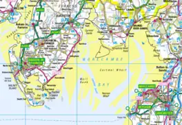
 Map of Morecambe Bay, showing almost all the route | |
| Length | 80 mi (130 km) |
| Location | Morecambe Bay (Cumbria and Lancashire), England |
| Established | 2015 |
| Designation | UK National Cycle Network |
| Trailheads | Walney Island (west) 54°6′9″N 3°15′45″W / 54.10250°N 3.26250°W Glasson Dock (east) 53°59′53″N 2°50′48″W / 53.99806°N 2.84667°W |
| Use | Cycling |
| Elevation change | 1777m[1] |
| Lowest point | start and finish, 0 m (0 ft) |
| Waymark | |
| Surface | 28.2% Traffic-free, 99.0% Asphalt |
| Website | Sustrans route description |
The Bay Cycle Way is an 80-mile (130 km) cycling route around Morecambe Bay in Lancashire and Cumbria in north west England.[2][3] Most of it forms National Cycle Route 700 (NCN 700), while other sections are waymarked as NCN 6 (London to the Lake District), NCN 69 (Hest Bank to Cleethorpes) and NCN 70 (Walney to Sunderland).[1]
It has been recommended by The Daily Telegraph ("20 amazing ways to enjoy the English seaside this summer"),[4] the i newspaper ("20 best cycle routes in the UK: from coastal pathways to woodland rides")[5] and the Touring Club Italiano ("Inghilterra, Scozia e Galles in bicicletta, le ciclabili più belle per una vacanza green").[6]
Route
The end points of the route are Walney Island, west of Barrow-in-Furness, and Glasson Dock, a former port on the River Lune south west of Lancaster.[7] The route goes inland to Milnthorpe to cross the River Kent at Levens Bridge, near Levens Hall, the lowest crossing point of the river by road; there are hopes that a footpath and cycleway may some time be installed alongside the railway viaduct which crosses the river at Arnside, further downstream.[8] 99.0% of the road is on asphalt roads or paths, and 28.2% is on traffic-free paths.[2] The route ascends to 170 metres (560 ft) between Grenodd and Cartmel,[9] and goes above 100 metres (330 ft) in three sections.[9] There are said to be three "challenging climbs": leaving Ulverston, ascending Bigland Hill (between Bigland Tarn and Bigland Barrow, north of Cartmel) and Warton Crag.[10] The total ascent has been calculated to be 1,777 metres (5,830 ft).[1] Sustrans estimates total cycling time as 6 h 46 min at an average pace of 12 miles per hour (19 km/h),[2] while the Morecambe Bay Partnership suggests a four-day itinerary.[11]
The route passes through:[11][9]
- Walney Island
- Barrow-in-Furness
- Rampside
- Roosebeck (8 miles (13 km))
- Ulverston (19 miles (31 km))
- Greenodd
- Cartmel
- Cark
- Flookburgh
- Grange-over-Sands (37 miles (60 km))
- River Kent crossing at Levens Bridge
- Arnside (53 miles (85 km))
- Silverdale
- Carnforth (outskirts) (62 miles (100 km))
- Hest Bank
- Morecambe (70 miles (110 km))
- Lancaster (73 miles (117 km))
- Glasson Dock (80 miles (130 km))
References
- 1 2 3 "The Bay Cycle Way- NCN 700". Sporty after Forty. Retrieved 27 June 2020.
- 1 2 3 "Bay Cycle Way". Sustrans. Retrieved 25 June 2020.
- ↑ "Bay Cycle Way". www.morecambebay.org.uk. Morecambe Bay Partnership. Retrieved 25 June 2020.
- ↑ Baxter, Sarah (25 June 2020). "20 amazing ways to enjoy the English seaside this summer". The Telegraph. Retrieved 25 June 2020.
- ↑ "20 best cycle routes in the UK: from coastal pathways to woodland rides". inews.co.uk. 29 March 2019. Retrieved 25 June 2020.
- ↑ Touring Club Italiano. "Inghilterra, Scozia e Galles in bicicletta, le ciclabili più belle per una vacanza green" (in Italian). Retrieved 25 June 2020.
- ↑ "Bay Cycle Way - Cycle Route in Morecambe, Morecambe Bay". www.visitlancashire.com. Visit Lancashire. Retrieved 25 June 2020.
- ↑ "£50,000 awarded to test Arnside viaduct walkway and cycle crossing". Cumbria Crack. 28 November 2018. Retrieved 25 June 2020.
- 1 2 3 "Bay Cycle Way". cycle.travel. Retrieved 26 June 2020.
- ↑ "Bay Cycle Way - The Route". www.morecambebay.org.uk. Morecambe Bay Partnership.
- 1 2 "Bay Cycle Way - 4 Day Itinerary". www.morecambebay.org.uk. Morecambe Bay Partnership. Retrieved 26 June 2020.
Further reading
- The Bay Cycle Way : cycle route map (2nd ed.). Sustrans. 2017. ISBN 978-1910845387.
External links
