Bayview, North Carolina | |
|---|---|
 Bayview  Bayview | |
| Coordinates: 35°26′13″N 76°47′31″W / 35.43694°N 76.79194°W | |
| Country | United States |
| State | North Carolina |
| County | Beaufort |
| Area | |
| • Total | 1.05 sq mi (2.73 km2) |
| • Land | 1.05 sq mi (2.73 km2) |
| • Water | 0.00 sq mi (0.00 km2) |
| Elevation | 7 ft (2 m) |
| Population (2020) | |
| • Total | 298 |
| • Density | 282.46/sq mi (109.02/km2) |
| Time zone | UTC-5 (Eastern (EST)) |
| • Summer (DST) | UTC-4 (EDT) |
| ZIP code | 27808[3] |
| Area code | 252 |
| GNIS feature ID | 1018990[2] |
| FIPS code | 37-04040 |
Bayview is an unincorporated community and census-designated place (CDP) in Beaufort County, North Carolina, United States. As of the 2010 census, it had a population of 346.[4]
The community is located on the north bank of the Pamlico River, south of North Carolina Highway 92.
Demographics
| Census | Pop. | Note | %± |
|---|---|---|---|
| 2020 | 298 | — | |
| U.S. Decennial Census[5] | |||
References
- ↑ "ArcGIS REST Services Directory". United States Census Bureau. Retrieved September 20, 2022.
- 1 2 U.S. Geological Survey Geographic Names Information System: Bayview, North Carolina
- ↑ "Bayview NC ZIP Code". zipdatamaps.com. 2023. Retrieved February 17, 2023.
- ↑ "Geographic Identifiers: 2010 Demographic Profile Data (G001): Bayview CDP, North Carolina". U.S. Census Bureau, American Factfinder. Archived from the original on February 12, 2020. Retrieved February 6, 2014.
- ↑ "Census of Population and Housing". Census.gov. Retrieved June 4, 2016.
Municipalities and communities of Beaufort County, North Carolina, United States | ||
|---|---|---|
| City | 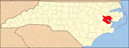 | |
| Towns | ||
| CDPs | ||
| Other communities | ||
This article is issued from Wikipedia. The text is licensed under Creative Commons - Attribution - Sharealike. Additional terms may apply for the media files.