| Belizean Coast mangroves | |
|---|---|
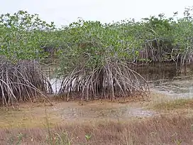
 Red mangrove in Belize | |
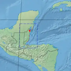
 Ecoregion territory | |
| Ecology | |
| Biome | Mangroves |
| Borders | |
| Geography | |
| Area | 2,850 km2 (1,100 sq mi) |
| Countries | |
| Conservation | |
| Conservation status | Vulnerable[1] |
The Belizean Coast mangroves ecoregion covers the brackish and salt-water habitats along the Caribbean Sea coast of Belize, and of Amatique Bay in Guatemala; small parts in the border with Mexico are also present on this ecoregion. The mangroves are partially protected from the open sea by the Belize Barrier Reef, and this ecoregion is distinct from the reef-based Belizean Reef mangroves ecoregion offshore.[2][3] There is a large population of the vulnerable West Indian manatee (Trichechus manatus) in the area. It covers an area of around 2850 km2.[4]
Location and description
The disconnected units of the ecoregion extend from the Mexico-Belize border in the north, to Amatique Bay on the southern coast of Guatemala. There are different types of mangrove swamps, depending on the site characteristics: river estuary (such as the Monkey River), lagoons, island atolls, and coastal forest. Technically, Belize City itself is in a mangrove area.
Offshore islands supporting mangroves include Ambergris Caye, the largest island of Belize, and the atoll reefs of Banco Chinchorro[5] and Turneffe Atoll.
Climate
The climate of the ecoregion is Tropical savanna climate - dry winter (Köppen climate classification (Aw)). This climate is characterized by relatively even temperatures throughout the year, and a pronounced dry season. The driest month has less than 60 mm (2.4 in) of precipitation, and is drier than the average month.[6][7]
Flora and fauna
The common mangrove tree species of the ecoregion are white mangrove (Laguncularia racemosa (generally closest to the ocean), red mangrove (Rhizophora mangle), and black mangrove (Avicennia germinans) (farther inland or upland). Also characteristic of the area, but not specifically to mangroves, is the buttonwood tree (Conocarpus erectus).[2]
Mammals of conservation interest include the near-threatened black howler monkey (Alouatta caraya), the critically endangered Hickatee turtle (Dermatemys mawii ), the tapir (Tapirus bairdii), the vulnerable West Indian manatee (Trichechus manatus), and Morelet's crocodile (Crocodylus moreletii).[8]
Protected areas
Protected areas of the ecoregion include:
- Shipstern Conservation & Management Area, in Corozal District of Belize
- Bacalar Chico National Park and Marine Reserve, on the northern part of Ambergris Island, in Belize District of Belize
- Payne's Creek National Park, in the Toledo District of southern Belize
- Sarstoon-Temash National Park,[8] in the Toledo District of southern Belize
References
- ↑ "Belizean Coast mangroves". Terrestrial Ecoregions. World Wildlife Fund. Retrieved 2013-08-24.
- 1 2 "Belizean reef mangroves". World Wildlife Federation. Retrieved November 20, 2020.
- ↑ "Map of Ecoregions 2017". Resolve, using WWF data. Retrieved November 20, 2020.
- ↑ "Belizean Coast mangroves". Fondo Mundial para la Naturaleza. Retrieved 2013-08-21.
- ↑ "Reserva de la Biosfera Banco Chinchorro". RAMSAR Sites Information Service. Retrieved November 20, 2020.
- ↑ Kottek, M., J. Grieser, C. Beck, B. Rudolf, and F. Rubel, 2006. "World Map of Koppen-Geiger Climate Classification Updated" (PDF). Gebrüder Borntraeger 2006. Retrieved September 14, 2019.
{{cite web}}: CS1 maint: multiple names: authors list (link) CS1 maint: numeric names: authors list (link) - ↑ "Dataset - Koppen climate classifications". World Bank. Retrieved September 14, 2019.
- 1 2 "Sarstoon Temash National Park". RAMSAR Sites Information Service. Retrieved November 20, 2020.
- World Wildlife Fund, ed. (2001). "Belizean Coast mangroves". WildWorld Ecoregion Profile. National Geographic Society. Archived from the original on 2010-03-08.
External links
 Media related to Belizean Coast mangroves at Wikimedia Commons