Belo | |
|---|---|
 Belo | |
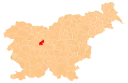
 Belo Location in Slovenia | |
| Coordinates: 46°4′44.13″N 14°21′36.94″E / 46.0789250°N 14.3602611°E | |
| Country | |
| Traditional region | Upper Carniola |
| Statistical region | Central Slovenia |
| Municipality | Medvode |
| Area | |
| • Total | 1.18 km2 (0.46 sq mi) |
| Elevation | 639.6 m (2,098.4 ft) |
| Population (2002) | |
| • Total | 27 |
| [1] | |
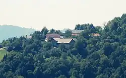
Belo (pronounced [ˈbeːlɔ]) is a small settlement in the Municipality of Medvode in the Upper Carniola region of Slovenia.[2] In the past it was known as Nawelim in German.[3]
Name
Belo was attested in historical documents as Weizzenperg in 1364, and as Wela, Nabela, and Vnnderwela in 1498, among other spellings.[4]
Cultural heritage
Several structures in Belo are registered as cultural heritage:
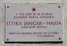
- The farm at Belo no. 1, known as the Lenart farm (Slovene: pr' Lenart), consists of a single-story stone house with a 16th-century foundation; the year 1858 is carved into the door casing. There is a cottage bearing the year 1827; this was a building used by a retired farmer that continued to live on the farm. Other structures include a granary with a cellar, a stone barn with a mow, a beehouse, a fruit-drying shed, and a hayrack.[5] There is also a plaque on the house commemorating the communist people's hero Lizika Jančar (a.k.a. Majda; 1919–1943), who was shot in Belo on 20 March 1943.[5][6]
- The house at Belo no. 2 stands on the eastern edge of the settlement, east of the farm at Belo no. 1. It is a two-story stone house from the end of the 20th century completely reconstructed from older architectural elements brought from elsewhere, including a door casing from green tuff, window casings, and beamed ceilings.[7]
 Plaque commemorating Lizika Jančar (1919–1943)
References
- ↑ Statistical Office of the Republic of Slovenia
- ↑ Medvode municipal site
- ↑ "Uebersicht der in Folge a. h. Entschließung vom 26. Juli 1849 genehmigten provisorischen Gerichtseintheilung des Kronlandes Krain". Intelligenzblatt zur Laibacher Zeitung. No. 141. November 24, 1849. p. 13.
- ↑ "Belo". Slovenska historična topografija. ZRC SAZU Zgodovinski inštitut Milka Kosa. Retrieved February 8, 2021.
- 1 2 Slovenian Ministry of Culture register of national heritage Archived April 7, 2015, at the Wayback Machine reference number ešd 9999
- ↑ Jakopič, Albert, & Franc Benedik. 1978. Vodnik po partizanskih poteh. Ljubljana: Borec, p. 60.
- ↑ Slovenian Ministry of Culture register of national heritage Archived April 7, 2015, at the Wayback Machine reference number ešd 16290
External links
 Media related to Belo at Wikimedia Commons
- Belo on Geopedia
This article is issued from Wikipedia. The text is licensed under Creative Commons - Attribution - Sharealike. Additional terms may apply for the media files.
