Benítez Municipality
Municipio Benítez | |
|---|---|
 | |
 Flag  Seal | |
 Location in Sucre | |
.svg.png.webp) Benítez Municipality Location in Venezuela | |
| Coordinates: 10°33′06″N 63°09′36″W / 10.5516°N 63.1601°W | |
| Country | |
| State | Sucre |
| Time zone | UTC−4 (VET) |
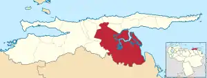
Benítez[1] is one of the 15 municipalities of Sucre State, Venezuela. It is located in the southeast of that State, it is the largest municipality of Sucre, it has an area of 2,733 km² and a population of 40,170 inhabitants (2011 census). Its capital is El Pilar.
The main economic activities are cocoa production that dates back to the time of the colony and river fishing.
The municipality is composed of six parishes; El Pilar, El Rincón, Francisco A. Vásquez, Guaraunos, Tunapuicito, and Unión.
History
The municipality was created on February 6, 1877 and bears its name in honor of Ramón Benítez, who stood out in the organization of the fight in Paria. Its capital, El Pilar, was founded on May 1, 1666, being the second town founded by the Aragonese Capuchins after Santamaría de Los Ángeles del Guácharo.
In 1909 the territorial political division of Venezuela was reorganized and the state of Sucre was given the political-territorial composition composed of nine districts, among which is the Benítez District, capital El Pilar. The now Benítez municipality covered an area of 2,733 km², up to the borders with the current Libertador municipality, represents a sixth of the territory of the state of Sucre.
Geography
The municipality is located in the southeastern part of the state off the coast of the Gulf of Paria in the Venezuelan Sea. The region is predominantly a plain dominated by a tropical jungle in which there are numerous pipes and rivers, there are areas of mangrove forests. The San Juan River is the main watercourse of the municipality, there is also the Caño de Ajíes and the asphalt lake of Guanoco. Among the protected areas are the Guarapiche Forest Reserve, declared in 1961, and the Turuépano National Park.
Benítez is the largest municipality in the state of Sucre. Its main feature is its tropical nature of jungles, rivers, pipes and sufar. It offers numerous attractions for adventure tourism, with its immense wetlands, the asphalt lake of Guanoco, the great San Juan river, the mangrove forests, the breeding of buffaloes, the virgin forests, and picturesque sites such as the Antonio Díaz ravine, with its limestone bed in which there are fossils of scholars and gastropods of great interest to geology. Remains of the old colonial splendor of its cocoa farms can also be seen. In the Guanaco pipe, specimens of the collection of river shrimp can be captured, investigated by specialists in the field. Of the very old tribes of the Guaraunos, their representatives are to the south of Guariquen, and samples of their work are exhibited in the Casa de la Cultura del Pilar.
It is bordered to the north by the municipalities of Arismendi and Bermúdez, to the east by the municipality of Libertador and the Gulf of Paria, to the south by the state of Monagas and to the west by the municipalities of Andrés Eloy Blanco and Andrés Mata.
Economy
The territory (the land) in which the Benítez municipality is located is ideal for the cultivation of cocoa, coffee and vegetables. In Europe, the flavor of Venezuelan cocoa was already known, and particularly that of the Gulf of Paria, so at the time of the Spanish colony the first cocoa haciendas and exports of cocoa and other products were undertaken through the port of Carúpano, years later its Corsican, Italian and German landowners and merchants; among them Cristino Wietstruck Lichtenberg opened the trade routes, developed agriculture and increased exports by building civil works to facilitate operations taking advantage of the fact that the municipality is very commercial due to its natural and strategic position that allows river communication having access to the sea through the Gulf of Paria and the Orinoco Delta by the Caño de Ajíes, it is also close to two main ports, Carúpano and Cumaná.
References
- ↑ "Wayback Machine" (PDF). web.archive.org. Retrieved 2023-12-31.