Bengkayang Regency
Kabupaten Bengkayang | |
|---|---|
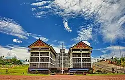 Office building of Bengkayang Regent | |
 Coat of arms | |
| Motto(s): Adil Ka' Talino (Fair to Others) | |
 Location within West Kalimantan | |
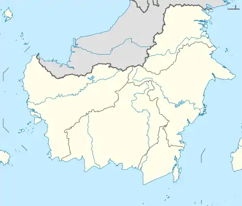 Bengkayang Regency Location in Kalimantan and Indonesia  Bengkayang Regency Bengkayang Regency (Indonesia) | |
| Coordinates: 1°04′09″N 109°39′50″E / 1.0691°N 109.6639°E | |
| Country | Indonesia |
| Province | West Kalimantan |
| Capital | Bengkayang |
| Government | |
| • Regent | Sebastianus Darwis |
| • Vice Regent | Syamsul Rizal |
| Area | |
| • Total | 5,382.74 km2 (2,078.29 sq mi) |
| Population (mid 2022 estimate)[1] | |
| • Total | 296,855 |
| • Density | 55/km2 (140/sq mi) |
| Time zone | UTC+7 (IWST) |
| Area code | (+62) 562 |
| Website | bengkayangkab |
Bengkayang Regency (Chinese: 孟嘉影) is a regency ("kabupaten") in West Kalimantan Province of Indonesia, (on the island of Borneo). The area was originally a part of Sambas Regency, but following the expansion of the population in that area, Sambas Regency was divided into a smaller Sambas Regency and a new Bengkayang Regency on 20 April 1999, and then Singkawang City was subsequently cut out of Bengkayang Regency on 21 June 2001. The regency now covers an area of 5,382.74 km2, and had a population of 215,277 at the 2010 Census[2] and 286,366 at the 2020 Census;[3] the official estimate as at mid 2022 was 296,855 (comprising 153,939 males and 142,916 females).[1] The administrative centre is in the town of Bengkayang.
Bengkayang is in northern West Kalimantan, sharing a border with Sarawak in Malaysia. With arable land and favourable relief, the agricultural sector is the main economic source.[4] Bengkayang is also rich in natural resources.
Bengkayang is still lagging in term of economic development, but there is a hope that providing local autonomy will catalyze development. A water processing plant has been developed, so the population can enjoy access to clean water.
Administrative districts
The regency is divided into seventeen districts (kecamatan), tabulated below with their areas and their populations at the 2010 Census[2] and the 2020 Census,[3] together with the official estimates as at mid 2022.[1] The table also includes the locations of the district administrative centres, the number of administrative villages in each district (a total of 122 rural desa and 2 urban kelurahan - the latter both in Bengkayang District), and its post code.
| Kode Wilayah | Name of District (kecamatan) |
Year formed | Area in km2 | Pop'n Census 2010 | Pop'n Census 2020 | Pop'n Estimate mid 2022 | Admin centre | No. of villages | Post code |
|---|---|---|---|---|---|---|---|---|---|
| 61.07.01 | Sungai Raya (Raya River) |
— | 75.85 | 18,333 | 23,497 | 23,994 | Sungai Duri | 5 | 79272 |
| 61.07.11 | Capkala | 2004 (from Sungai Raya) |
46.36 | 7,579 | 9,655 | 9,836 | Capkala | 6 | 79271 |
| 61.07.15 | Sungai Raya Kepulauan (Raya River Islands)(a) |
2006 (from Sungai Raya) |
237.87 | 20,922 | 29,015 | 30,556 | Sungai Raya | 5 | 79273 |
| 61.07.02 | Samalantan | — | 234.69 | 18,240 | 22,882 | 23,170 | Samalantan | 7 | 79280 |
| 61.07.08 | Monterado | 2002 (from Samalantan) |
317.17 | 24,453 | 33,530 | 35,155 | Monterado | 11 | 79181 |
| 61.07.16 | Lembah Bawang (Onion Valley) |
2006 (from Samalantan) |
360.80 | 5,191 | 6,476 | 6,544 | Papan Uduk | 8 | 79281 |
| 61.07.04 | Bengkayang | — | 167.05 | 23,764 | 33,385 | 35,333 | Sebalo | 6 | 79212 & 79213 |
| 61.07.09 | Teriak | 2002 (from Bengkayang) |
299.70 | 12,464 | 17,001 | 17,789 | Bana | 18 | 79214 |
| 61.07.14 | Sungai Betung (Betung River) |
2004 (from Bengkayang) |
182.39 | 8,919 | 12,193 | 12,769 | Suka Maju | 4 | 79211 |
| 61.07.03 | Ledo | — | 408.48 | 11,076 | 14,274 | 14,607 | Lesabela | 12 | 79283 |
| 61.07.10 | Suti Semarang | 2002 (from Ledo) |
357.85 | 4,579 | 5,972 | 6,140 | Suti Semarang | 8 | 79288 |
| 61.07.13 | Lumar | 2004 (from Ledo) |
373.51 | 5,764 | 8,111 | 8,590 | Tiga Berkat | 5 | 79282 |
| 61.07.06 | Sanggau Ledo | — | 273.05 | 11,198 | 15,197 | 15,869 | Lembang | 5 | 79284 |
| 61.07.17 | Tujuh Belas | 2006 (from Sanggau Ledo) |
323.13 | 11,216 | 15,243 | 15,925 | Pisak | 4 | 79250 |
| 61.07.05 | Seluas | — | 506.50 | 17,051 | 20,930 | 21,014 | Seluas | 6 | 79285 |
| 61.07.07 | Jagoi Babang | 1996 (from Seluas) |
655.02 | 8,277 | 10,848 | 11,175 | Jagoi | 6 | 79286 |
| 61.07.12 | Siding | 2004 (from Jagoi Babang) |
563.32 | 6,251 | 8,157 | 8,389 | Hlibuie | 8 | 79287 |
| Totals | 5,382.74 | 215,277 | 286,366 | 296,855 | Bengkayang | 124 |
Note: (a) includes coastal part of mainland Kalimantan as well as 12 offshore islands.
List of Bengkayang Regents and Vice Regents
| Regent | Vice Regent | Took Office | Last Office | Notice |
|---|---|---|---|---|
| Jacobus Luna | 1999 | 2000 | ||
| Moses Ahie | 2000 | 2005 | First Period | |
| Suryadman Gidot | 2005 | 2010 | Second Period | |
| Suryadman Gidot | Agustinus Naon | 2010 | 2015 | First Period |
| 2015 | 2019 | Second Period | ||
| Agustinus Naon | 2019 | 2020 | Acting | |
| Yohanes Budiman | 2020 | 2020 | Acting | |
| Sebastianus Darwis | Syamsul Rizal | 2021 | present |
Climate
Bengkayang has a tropical rainforest climate (Af) with heavy rainfall year-round.
| Climate data for Bengkayang | |||||||||||||
|---|---|---|---|---|---|---|---|---|---|---|---|---|---|
| Month | Jan | Feb | Mar | Apr | May | Jun | Jul | Aug | Sep | Oct | Nov | Dec | Year |
| Mean daily maximum °C (°F) | 29.4 (84.9) |
29.7 (85.5) |
30.4 (86.7) |
30.8 (87.4) |
31.3 (88.3) |
31.0 (87.8) |
30.8 (87.4) |
30.8 (87.4) |
30.7 (87.3) |
30.7 (87.3) |
30.3 (86.5) |
29.9 (85.8) |
30.5 (86.9) |
| Daily mean °C (°F) | 25.7 (78.3) |
25.9 (78.6) |
26.2 (79.2) |
26.5 (79.7) |
26.8 (80.2) |
26.6 (79.9) |
26.3 (79.3) |
26.4 (79.5) |
26.4 (79.5) |
26.5 (79.7) |
26.3 (79.3) |
26.0 (78.8) |
26.3 (79.3) |
| Mean daily minimum °C (°F) | 22.0 (71.6) |
22.2 (72.0) |
22.1 (71.8) |
22.3 (72.1) |
22.4 (72.3) |
22.2 (72.0) |
21.9 (71.4) |
22.0 (71.6) |
22.2 (72.0) |
22.4 (72.3) |
22.3 (72.1) |
22.2 (72.0) |
22.2 (71.9) |
| Average rainfall mm (inches) | 307 (12.1) |
237 (9.3) |
243 (9.6) |
268 (10.6) |
240 (9.4) |
172 (6.8) |
142 (5.6) |
190 (7.5) |
211 (8.3) |
307 (12.1) |
331 (13.0) |
325 (12.8) |
2,973 (117.1) |
| Source: Climate-Data.org[5] | |||||||||||||
References
- 1 2 3 Badan Pusat Statistik, Jakarta, 2023, Kabupaten Bengkayang Dalam Angka 2023 (Katalog-BPS 1102001.6107)
- 1 2 Biro Pusat Statistik, Jakarta, 2011.
- 1 2 Badan Pusat Statistik, Jakarta, 2021.
- ↑ "Gross Regional Domestic Product (GRDP) of Bengkayang Regency at market price in 2005 was 1". Archived from the original on 2011-08-19. Retrieved 2011-06-08.
- ↑ "Climate: Bengkayang". Climate-Data.org. Retrieved 24 November 2020.
Regencies and cities of West Kalimantan | ||
|---|---|---|
Capital: Pontianak | ||
| Regencies | ||
| Cities | ||
1°04′09″N 109°39′50″E / 1.0691°N 109.6639°E