Bergerville, New Jersey | |
|---|---|
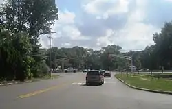 Looking east along Bergerville Road towards US 9 | |
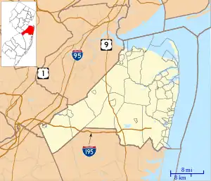 Bergerville, New Jersey Location of Bergerville in Monmouth County Inset: Location of county within the state of New Jersey  Bergerville, New Jersey Bergerville, New Jersey (New Jersey)  Bergerville, New Jersey Bergerville, New Jersey (the United States) | |
| Coordinates: 40°12′07″N 74°15′42″W / 40.20194°N 74.26167°W | |
| Country | |
| State | |
| County | Monmouth |
| Township | Howell |
| Elevation | 89 ft (27 m) |
| GNIS feature ID | 883199[1] |
Bergerville is an unincorporated community located within Howell Township in Monmouth County, in the U.S. state of New Jersey.[2] The area was originally developed as a resort bungalow community in the first half of the 20th century.[3][4]
The settlement is centered on the intersection of U.S. Route 9 (which runs north and south), Bergerville Road (which runs west towards Freehold Township) and Casino Drive (which runs east towards the Manasquan Reservoir). Commercial businesses line US 9 through the area and some single-family houses are located along the two main east–west roads and Fort Plains Road. Numerous condominium and town house developments are also located nearby.[5]
References
- 1 2 "Bergerville". Geographic Names Information System. United States Geological Survey, United States Department of the Interior.
- ↑ "NJDOT Graphic Information System Maps Middlesex" (PDF). New Jersey Department of Transportation. Retrieved March 29, 2020.
- ↑ "Guests hold fond memories of resort – Central Jersey Archives".
- ↑ Navarra, Tova; Briggs, Bob (April 20, 1996). Howell and Farmingdale: A Social and Cultural History. Arcadia Publishing. ISBN 9780752402833 – via Google Books.
- ↑ Google (February 17, 2015). "Bergerville, New Jersey" (Map). Google Maps. Google. Retrieved February 17, 2015.

This article is issued from Wikipedia. The text is licensed under Creative Commons - Attribution - Sharealike. Additional terms may apply for the media files.