Bergh | |
|---|---|
former municipality | |
.jpg.webp) Bergh skyline | |
 Flag  Coat of arms | |
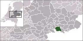
 Location of Bergh within Gelderland | |
 Bergh Former municipality of Bergh located within the province of Gelderland | |
| Coordinates: 51°53′N 6°15′E / 51.883°N 6.250°E | |
| Country | Netherlands |
| Province | Gelderland |
| Established | 1821 |
| Disestablished & merged | 2005 |
| Area | |
| • Total | 74.98 km2 (28.95 sq mi) |
| Time zone | UTC+1 (CET) |
| • Summer (DST) | UTC+2 (CEST) |
| Postcode | 10350 |
| Website | HeemkundekringBergh.nl |
Bergh is a former municipality in the Dutch province of Gelderland. The municipality included the villages of 's-Heerenberg, Zeddam, and Stokkum.
In 2005, it merged with Didam to form the new municipality of Montferland.
External links
![]() Media related to Bergh at Wikimedia Commons
Media related to Bergh at Wikimedia Commons
- Oude kaart Bergh 1, Gelderland — maps of the municipality in 1868
- Oude kaart Bergh 2, Gelderland — maps of the municipality in 1868
This article is issued from Wikipedia. The text is licensed under Creative Commons - Attribution - Sharealike. Additional terms may apply for the media files.