| Berremangra New South Wales | |||||||||||||||
|---|---|---|---|---|---|---|---|---|---|---|---|---|---|---|---|
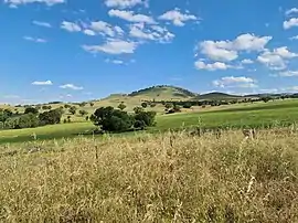
 Berremangra Hill | |||||||||||||||
 Berremangra Location in New South Wales | |||||||||||||||
| Coordinates | 34°47′55″S 148°28′4″E / 34.79861°S 148.46778°E | ||||||||||||||
| Population | 87 (SAL 2021)[1] | ||||||||||||||
| Postcode(s) | 2582 | ||||||||||||||
| Location |
| ||||||||||||||
| LGA(s) | Hilltops Council | ||||||||||||||
| Region | South West Slopes | ||||||||||||||
| County | Harden | ||||||||||||||
| Parish | Coppabella | ||||||||||||||
| State electorate(s) | Cootamundra | ||||||||||||||
| Federal division(s) | Hume | ||||||||||||||
| |||||||||||||||
Berremangra is a locality in the Hilltops Council, New South Wales, Australia.[2][3] It is on both sides of the Hume Highway about 45 km west of Yass.
At the 2016 census, it had a population of 81,[4] which had grown to 87 in 2021.[5]
Berremangra had a public school described as a "provisional school" from 1872 to 1892, from 1905 to 1913 and from 1919 to 1920. It had a "half-time" school from 1913 to 1915, sharing its teacher with Bookham. It had a public school from 1959 to 1968.[6]
References
- ↑ Australian Bureau of Statistics (28 June 2022). "Berremangra (suburb and locality)". Australian Census 2021 QuickStats. Retrieved 28 June 2022.
- ↑ "Berremangra". Geographical Names Register (GNR) of NSW. Geographical Names Board of New South Wales. Retrieved 18 January 2021.
- ↑ "Berremangra". OpenStreetMap. Retrieved 18 January 2021.
- ↑ Australian Bureau of Statistics (27 June 2017). "Berremangra". 2016 Census QuickStats. Retrieved 18 January 2021.
- ↑ "2021 Berremangra, Census All persons QuickStats". Australian Bureau of Statistics. Retrieved 15 August 2022.
- ↑ "Berremangra in the School history database search". New South Wales Department of Education. Retrieved 18 January 2021.
This article is issued from Wikipedia. The text is licensed under Creative Commons - Attribution - Sharealike. Additional terms may apply for the media files.