| Bethania | |
|---|---|
.jpg.webp) | |
| Country | Wales, United Kingdom |
| Denomination | Independent (Congregationalist) |
| History | |
| Founded | 1850 |
| Architecture | |
| Heritage designation | Grade II listed building |
| Designated | 18 February 1999 |
| Architectural type | Chapel |
| Style | Mid-19th century |
| Completed | 1859 |
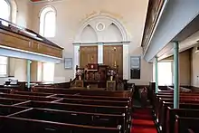
Bethania is an Independent chapel in Phillip Street, Mountain Ash, Glamorgan, Wales. Services at Bethania are conducted in the Welsh language.
Early history

The church began in the form of a Sunday school built in 1850, although earlier meetings had been held at the home of one Daniel Rowlands, which later became the Glancynon Inn.[1] The first chapel was built in 1854 at a cost of £320, but became too small as a result of the religious revival of 1859.[1] A new chapel was therefore built at a cost of £950 with seating for 750.[1] This coincided with the sinking of the Deep Duffryn Colliery in 1855, which led to a large influx of people into the area.
David Edward Coleman (Eos Hefin), also known as Coleman Bach (Little Coleman), was a prominent member of Bethania. For many years he conducted the chapel choir and was one of the conductors of the South Wales Choral Union which won the first prize at a celebrated choral competition at the Crystal Palace in London in 1872.[1] Coleman kept a grocery and drapery business at 54 Commercial Street, Mountain Ash.
The chapel was enlarged in 1887 and a new vestry built alongside.[1] Thomas Llewellyn was minister from 1854 until 1888.[1] He was succeeded by Owen Jones, who remained until 1909.[2]
Twentieth century
John Phillips was minister from 1911 until 1945 and Haydn Davies from 1950 until 1960.[1]
The chapel remains beautifully preserved and maintained. There were 20 members in 2004. Mountain Ash and District Choral Society hold their practices and rehearsals at the vestry.[1]
References
Bibliography
- Jones, Alan Vernon (2004). Chapels of the Cynon Valley. Cynon Valley Historical Society. ISBN 0953107612.
External links
 Media related to Capel Bethania, Aberpennar at Wikimedia Commons
- Cadw listing