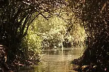
The Bethsaida Valley (Hebrew: בקעת הבטיחה), Arabic: Buq'at al-Butayhah,[1] is a valley by the northeast shores of the Sea of Galilee at the steep foothills of the central Golan Heights.[2]
Etymology

Bethsaida Valley is named after the town of Bethsaida, best known from the New Testament. In Hebrew beit means house, and tzed means both hunting and fishing.[3] The resulting name means either "house of the fisherman" or "house of the hunter".[4] The Hebrew Beit-tzaida, adapted to Greek phonetics (the New Testament was written in Greek) and transliterated to Latin, yields Bethsaida.[3]
The Arabic name of the valley is Buq'at al-Butayhah, also spelled Bik'at Beteiha,[1][5] or el-Batikha.[6][7]
Wetlands
The Jordan River and the streams coming down from the Central Golan create a landscape of swamps and open water surfaces, variously called deltas, estuaries or lagoons.
The following five rivers or streams flow through the valley (west to east): Jordan, whose upper course ends here, at the northern edge; then Meshushim (Wadi el-Hawa in Arabic; collects the waters of the Katzrin and Zavitan streams), Yehudiya (with Batra as a tributary), Daliyot, and Sfamnun/Sfamnon (Hebrew: נחל שפמנון Nahal Sfamnon). The wetlands are protected as part of the Majrase – Betiha (Bethsaida Valley) Nature Reserve.[8] The reserve covers 6.930 dunams,[9] some of it agricultural land,[10] and represents a sequence of habitats (river, marshland, lagoon, and lake habitat).[9]
The Meshushim River, which has already received the waters of Zavitan, and the Yehudiya River, merge shortly before reaching the lake and form the Zaki estuary, while Daliyot River creates the Majrase[11] or Majrassa estuary, also known as the Daliyot River estuary. The Majrase is the largest freshwater nature reserve controlled by Israel.[10]
Archaeology
Multiple archaeological sites, including dolmens, suggest that it was settled by farmers and fishermen since the early Bronze Age. From the Second Temple period through the Byzantine period it was densely populated.[8]
References
- 1 2 Buq‘at al Buţayḩah, Israel, Mindat.org, accessed 23.1.2022.
- ↑ "About the Golan", galilandgolan.com, re-accessed 23 Jan 2022.
- 1 2 "Where Is Biblical Bethsaida, Where Jesus Walked on Water? The Case of This Jordan River Mound". Ruth Schuster for Haaretz. 19 August 2020. Retrieved 24 January 2022.
- ↑ Franz, Gordon (10 November 2007). "Text and Tell: The Excavations at Bethsaida". PlymouthBrethren.org (2nd,revised and updated from the one published in Archaeology in the Biblical World, (1995) 3/1: 6-11 ed.). Retrieved 24 January 2022.
- ↑ Ben-Avraham, Zvi et al. (1980). "Magnetic survey of Lake Kinneret–central Jordan Valley, Israel". Marine Geophysical Researches 4 p. 269. doi:10.1007/bf00369102. Accessed 23 Jan 2022.
- ↑ Picard, Leo (2021) [1996]. Erhard Roy Wiehn (ed.). Vom Bodensee nach Erez Israel: Pionierarbeit für Geologie und Grundwasser seit 1924 (in German). Konstanz: Hartung-Gorre. p. 113. ISBN 978-3891917992. Retrieved 23 January 2022.
- ↑ The Ministry of Health Advises to Visit Israel's North as Normal, 15.8.2018, accessed 23.1.2022.
- 1 2 "The Majrase – Betiha (Bethsaida Valley) Nature Reserve". Jerusalem: Israel Nature and Parks Authority. 2019. Retrieved 19 January 2022.
- 1 2 Goldstein, Hava; Kaplan, Didi (27 May 2004). "השפעות סביבתיות בפיתוח שמורת הבטיחה" [Environmental impacts in the development of the Betiha Reserve]. Jerusalem: Israel Nature and Parks Authority. Archived from the original on 3 January 2016. Retrieved 24 January 2022.
- 1 2 "Majrassa Nature Reserve". Attractions-in-israel.com. 20 September 2011. Archived from the original on 1 July 2019. Retrieved 16 June 2019.
- ↑ Bar-Am, Aviva (2008). Israel's Northern Landscapes: Guide to the Golan Heights, Eastern Galilee and Lake Kinneret. Retrieved 23 January 2022 – via The Jerusalem Post, "A river runs through it", 7 August 2008.