| Bever | |
|---|---|
 | |
| Location | |
| Country | Germany |
| State | North Rhine-Westphalia |
| Physical characteristics | |
| Source | |
| • location | district In den Eicken of Halver |
| • coordinates | 51°11′05″N 7°26′07″E / 51.1848°N 7.4353°E |
| Mouth | |
• location | district Hartkopsbever of Hückeswagen, into the Wupper |
• coordinates | 51°08′28″N 7°21′10″E / 51.1410°N 7.3529°E |
| Length | 10.0 km (6.2 mi) [1] |
| Basin features | |
| Progression | Wupper→ Rhine→ North Sea |
| Tributaries | |
| • right | Moorbach, Erlenbach, Scheuerbach |
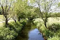
Bever is a river of North Rhine-Westphalia, Germany.
After being dammed by the Bevertalsperre into the Beverteich,[2] it flows into the Wupper in Hückeswagen.
See also
References
- ↑ Hydrographic Directory of the NRW State Office for Nature, the Environment and Consumer Protection (Gewässerverzeichnis des Landesamtes für Natur, Umwelt und Verbraucherschutz NRW 2010) (xls; 4.67 MB)
- ↑ Google (26 September 2018). "Beverteich" (Map). Google Maps. Google. Retrieved 26 September 2018.
This article is issued from Wikipedia. The text is licensed under Creative Commons - Attribution - Sharealike. Additional terms may apply for the media files.