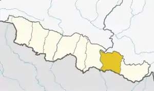
Bhagwanpur
भगवानपुर | |
|---|---|
 Bhagwanpur Location in Nepal | |
| Coordinates: 26°35′N 86°28′E / 26.58°N 86.47°E | |
| Country | |
| Province | Province No. 2 |
| District | Siraha District |
| Government | |
| • Chariperson | Bechan Prasad Yadav |
| • Vice-Chariperson | Sita Devi Yadav |
| Population (2011) | |
| • Total | 20,957 |
| Languages | |
| • Local | Maithali |
| Time zone | UTC+5:45 (Nepal Time) |
| Area code | 033 |
| Website | http://www.bhagwanpurmun.gov.np/ |
Bhagwanpur is a rural municipality in Siraha District in Province No. 2 of south-eastern Nepal. At the time of the 2011 Nepal census it had a population of 20957 people living.[1] It is located nearly 370 kilometers or 107 miles east of the capital, Kathmandu.
Thadi (Nepali: ठाड़ी) or Thadi Viswaspatti is the main market place in the municipality and a very old border town and a market place of Nepal in Siraha District bordering Indian town of Laukaha.
Thadi is one of the few towns which is a part of agreed route for Mutual Trade between India and Nepal.[2] Nepal Government has set up a dedicated customs office in the town.[3]
The town connects Lahan, Nepal to India.
Demographics
At the time of the 2011 Nepal census, Bhagwanpur Rural Municipality had a population of 20,999. Of these, 95.9% spoke Maithili, 1.7% Tharu, 1.1% Urdu, 0.3% Nepali, 0.1% spoke Gurung and 0.2% other languages as their first language.[4]
In terms of ethnicity/caste, 34.7% were Yadav, 9.1% Teli, 6.9% Dhanuk, 6.7% Khatwe, 6.5% Dusadh/Paswan/Pasi, 5.1% Musalman, 4.3% Chamar/Harijan/Ram, 3.8% Musahar, 2.0% Tharu, 1.9% Kumhar, 1.8% Halwai, 1.8% Kayastha, 1.6% Dhobi, 1.4% Kewat, 1.3% Sudhi, 1.2% Hajam/Thakur, 1.2% Tatma/Tatwa, 1.1% Baraee, 1.0% Kathabaniyan, 1.0% Mallaha, 0.9% Terai Brahmin, 0.8% Koiri/Kushwaha, 0.6% Hill Brahmin, 0.5% Danuwar, 0.5% Kalwar, 0.5% Majhi, 0.3% Kumal, 0.3% Sanyasi/Dasnami, 0.2% Mali, 0.1% Chhetri, 0.1% Dom, 0.1% Kami, 0.1% Kusunda, 0.1% Lohar, 0.1% Marwadi, 0.1% Rajput, 0.1% Sonar and 0.2% others.[5]
In terms of religion, 94.8% were Hindu, 5.1% Muslim and 0.1% others.[6]
In terms of literacy, 50.1% could read and write, 1.8% could only read and 48.0% could neither read nor write.[7]
Infrastructure
Rajbiraj Airport is the nearest airport, roughly 35 km away from Thadi. Shree Airlines operates daily flights between Rajbiraj and Kathmandu[8]
The town is also connected to Laukaha Bazar railway station which is located in adjacent Indian town of Laukaha. The 268 km (167 mi) long Jainagar-Darbhanga-Narkatiaganj line and Sakri-Laukaha Bazar-Nirmali line were converted from metre to broad gauge in 2011–2012.[9]
There are various bus operators who operate direct bus from Thadi in Bhagwanpur to Kathmandu via Lahan, Nepal which is 18 kn north of Thadi[10] and also connects to Mahendra Highway. It is one of the major routes for tourist from India to go to travel Nepal.
References
- ↑ "Nepal Census 2001". Nepal's Village Development Committees. Digital Himalaya. Archived from the original on 12 October 2008. Retrieved 17 November 2008.
- ↑ "India Nepal Trade Agreement. India-Nepal Foreign Treaty of Trade Agreement". www.eximguru.com. Retrieved 2019-09-12.
- ↑ "Department of Customs, Nepal - Custom Contact Offices". www.customs.gov.np. Archived from the original on 2019-09-25. Retrieved 2019-09-12.
- ↑ NepalMap Language
- ↑ NepalMap Caste
- ↑ NepalMap Religion
- ↑ NepalMap Literacy
- ↑ Rai, Pinkey (24 April 2019). "Rajbiraj Airport to resume its flight services from May 8 as Shree Airline prepares for flight operation". Aviation Nepal. Retrieved 11 September 2019.
- ↑ "Assets-Acquisition, Construction and Replacement for 2011-12" (PDF). East Central Railway. Retrieved 2013-03-04.
- ↑ "Locals in border areas deprived of state facilities".
External links
