Białopole | |
|---|---|
Village | |
 House in Białopole in 2019 | |
 Białopole  Białopole | |
| Coordinates: 50°52′49″N 14°54′04″E / 50.88028°N 14.90111°E | |
| Country | |
| Voivodeship | Lower Silesian |
| County | Zgorzelec |
| Gmina | Bogatynia |
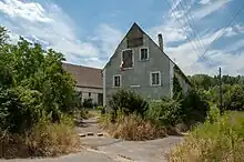
A house in Białopole
Białopole [bjawɔˈpɔlɛ] is a village in the administrative district of Gmina Bogatynia, within Zgorzelec County, Lower Silesian Voivodeship, in south-western Poland, close to the Czech and German borders.[1]
It lies approximately 7 kilometres (4 mi) south-west of Bogatynia, 31 kilometres (19 mi) south of Zgorzelec, and 153 kilometres (95 mi) west of the regional capital Wrocław.
References
Wikimedia Commons has media related to Białopole, Lower Silesian Voivodeship.
| Town and seat |  | |
|---|---|---|
| Villages | ||
This article is issued from Wikipedia. The text is licensed under Creative Commons - Attribution - Sharealike. Additional terms may apply for the media files.