Birjand County
Persian: شهرستان بیرجند | |
|---|---|
County | |
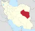
.svg.png.webp) Location of Birjand County in South Khorasan province | |
 Location of South Khorasan province in Iran | |
| Coordinates: 33°05′N 59°10′E / 33.083°N 59.167°E[1] | |
| Country | Iran |
| Province | South Khorasan |
| Capital | Birjand |
| Districts | Central |
| Population (2016)[2] | |
| • Total | 261,324 |
| Time zone | UTC+3:30 (IRST) |
| Birjand County at GEOnet Names Server | |
Birjand County (Persian: شهرستان بیرجند) is in South Khorasan province, Iran. Its capital is the city of Birjand.[3]
At the 2006 census, the county's population was 221,756 in 60,240 households.[4] The following census in 2011 counted 259,506 people in 71,384 households.[5] At the 2016 census, the county's population was 261,324 in 74,657 households,[2] by which time Khusf District had been separated from the county in the establishment of Khusf County.[6]
Administrative divisions
The population history and structural changes of Birjand County's administrative divisions over three consecutive censuses are shown in the following table. The latest census shows one district, six rural districts, and one city.[2]
After the census, Shakhen and Shakhenat Rural Districts were separated from the Central District in the establishment of Shakhenat District.[7]
| Administrative Divisions | 2006[4] | 2011[5] | 2016[2] |
|---|---|---|---|
| Central District | 196,834 | 230,487 | 261,324 |
| Alqurat RD | 8,236 | 12,026 | 9,479 |
| Baqeran RD | 14,651 | 26,940 | 34,071 |
| Fasharud RD | 2,727 | 2,124 | 2,435 |
| Kahshang RD | 3,991 | 3,338 | 3,737 |
| Shakhen RD | 6,276 | 5,130 | 5,372 |
| Shakhenat RD | 3,105 | 2,909 | 2,594 |
| Birjand (city) | 157,848 | 178,020 | 203,636 |
| Khusf District1 | 24,922 | 29,019 | |
| Barakuh RD | 3,919 | 2,496 | |
| Jolgeh-ye Mazhan RD | 4,280 | 4,536 | |
| Khusf RD | 9,419 | 11,464 | |
| Qaleh Zari RD | 4,118 | 3,896 | |
| Khusf (city) | 3,186 | 4,920 | |
| Mohammadshahr (city) | 1,707 | ||
| Shakhenat District2 | |||
| Shakhen RD | |||
| Shakhenat RD | |||
| Total | 221,756 | 259,506 | 261,324 |
| RD: Rural District 1Became a part of Khusf County[6] 2Established after the 2016 census[7] | |||
References
- ↑ OpenStreetMap contributors (18 March 2023). "Birjand County" (Map). OpenStreetMap. Retrieved 18 March 2023.
- 1 2 3 4 "Census of the Islamic Republic of Iran, 1395 (2016)". AMAR (in Persian). The Statistical Center of Iran. p. 29. Archived from the original (Excel) on 17 October 2020. Retrieved 19 December 2022.
- ↑ Habibi, Hassan (21 June 1369). "Approval of the organization and chain of citizenship of the elements and units of the divisions of Khorasan province, centered in Mashhad". Lamtakam (in Persian). Ministry of Interior, Defense Political Commission of the Government Council. Archived from the original on 27 December 2023. Retrieved 27 December 2023.
- 1 2 "Census of the Islamic Republic of Iran, 1385 (2006)". AMAR (in Persian). The Statistical Center of Iran. p. 29. Archived from the original (Excel) on 20 September 2011. Retrieved 25 September 2022.
- 1 2 "Census of the Islamic Republic of Iran, 1390 (2011)". Syracuse University (in Persian). The Statistical Center of Iran. p. 29. Archived from the original (Excel) on 20 January 2023. Retrieved 19 December 2022.
- 1 2 Rahimi, Mohammad Reza (6 May 2012). "Approval letter regarding country divisions in South Khorasan province (Birjand County)" (PDF). RRK (in Persian). Ministry of Interior, Council of Ministers. Archived from the original (PDF) on 9 November 2023. Retrieved 9 November 2023.
- 1 2 Jahangiri, Ishaq (15 February 1400). "Letter of approval regarding country divisions in Birjand County, South Khorasan province". Qavanin (in Persian). Ministry of Interior, Council of Ministers. Archived from the original on 19 March 2023. Retrieved 19 March 2023.


