Björnlunda | |
|---|---|
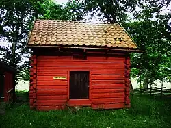
 Björnlunda hembygdsgård | |
 Björnlunda  Björnlunda | |
| Coordinates: 59°04′N 17°09′E / 59.067°N 17.150°E | |
| Country | Sweden |
| Province | Södermanland |
| County | Södermanland County |
| Municipality | Gnesta Municipality |
| Area | |
| • Total | 0.86 km2 (0.33 sq mi) |
| Population (31 December 2010)[1] | |
| • Total | 827 |
| • Density | 962/km2 (2,490/sq mi) |
| Time zone | UTC+1 (CET) |
| • Summer (DST) | UTC+2 (CEST) |
| Climate | Dfb |
Björnlunda is a locality situated in Gnesta Municipality, Södermanland County, Sweden with 827 inhabitants in 2010.[1] Björnlunda is located between the city of Södertälje and the city of Katrineholm and close to halfway between Strängnäs and Nyköping in a north–south direction.
History
The earliest citation for Björnlunda is in a document dating from around 1314 in which the settlement is called "Biornlundum". However, there are traces of Viking-era settlement and there are Iron Age graves in the area.[2]
For a long time the nearby village of Önnersta was the main settlement in the area, as it lay on the route used by Swedish monarchs travelling between Gripsholm Castle and Nyköpingshus. However, the establishment of a railway line between Stockholm and Gothenburg in 1862 led to a gradual drift of markets and population to the area nearest the new railway station in Björnlunda, which became the dominant settlement in the area.[2]
Riksdag elections
| Year | % | Votes | V | S | MP | C | L | KD | M | SD | NyD | Left | Right |
|---|---|---|---|---|---|---|---|---|---|---|---|---|---|
| 1973[3] | 89.4 | 668 | 3.4 | 34.3 | 40.1 | 8.5 | 1.3 | 10.9 | 37.7 | 59.6 | |||
| 1976[4] | 88.7 | 771 | 3.5 | 32.9 | 39.4 | 8.0 | 1.2 | 14.5 | 36.4 | 62.0 | |||
| 1979[5] | 86.4 | 771 | 3.4 | 36.1 | 33.5 | 8.9 | 0.6 | 17.3 | 39.4 | 59.7 | |||
| 1982[6] | 85.6 | 785 | 3.3 | 35.9 | 3.7 | 25.7 | 4.6 | 1.3 | 25.4 | 39.2 | 55.7 | ||
| 1985[7] | 87.5 | 827 | 3.6 | 32.8 | 2.9 | 20.8 | 14.4 | 25.3 | 36.4 | 60.5 | |||
| 1988[8] | 85.0 | 776 | 4.4 | 32.7 | 6.1 | 20.6 | 11.3 | 2.4 | 22.3 | 43.2 | 54.3 | ||
| 1991[9] | 88.4 | 846 | 3.8 | 31.1 | 4.5 | 17.0 | 8.7 | 4.8 | 19.6 | 9.3 | 34.9 | 50.2 | |
| 1994[10] | 86.8 | 858 | 6.0 | 36.3 | 6.9 | 16.7 | 6.2 | 3.6 | 21.3 | 1.1 | 49.2 | 47.8 | |
| 1998[11] | 80.2 | 787 | 8.9 | 31.4 | 6.0 | 14.2 | 4.3 | 13.2 | 20.6 | 46.3 | 52.4 | ||
| 2002[12] | 81.1 | 821 | 8.9 | 32.2 | 6.1 | 14.9 | 11.1 | 11.3 | 13.2 | 1.1 | 47.1 | 50.4 | |
| 2006[13] | 82.3 | 836 | 4.3 | 29.7 | 6.5 | 13.6 | 5.4 | 6.6 | 28.8 | 3.3 | 40.4 | 54.4 | |
| 2010[14] | 82.8 | 896 | 4.8 | 23.0 | 7.8 | 11.5 | 6.0 | 3.8 | 33.6 | 7.8 | 35.6 | 54.9 | |
| 2014[15] | 86.6 | 923 | 5.3 | 25.2 | 6.0 | 11.5 | 3.9 | 3.5 | 25.7 | 15.1 | 36.5 | 44.5 | |
| 2018[16] | 85.7 | 913 | 8.8 | 23.2 | 3.8 | 14.0 | 3.7 | 5.3 | 18.9 | 20.6 | 49.8 | 48.5 |
Attractions
Jägerdals Gård, Haversjön, The local museum, Dagnäsön, Björnlunda Church, Öster Malma, Laxne, Krampan, Skottvångs gruva, Näsberget, Jätkyrkan, Kyrksjön, Kleva kvarn.
References
- 1 2 3 "Tätorternas landareal, folkmängd och invånare per km2 2005 och 2010" (in Swedish). Statistics Sweden. 14 December 2011. Archived from the original on 27 January 2012. Retrieved 10 January 2012.
- 1 2 "Björnlundas historia".
- ↑ "Allmänna valen 1973" (PDF) (in Swedish). SCB.
- ↑ "Allmänna valen 1976" (PDF) (in Swedish). SCB.
- ↑ "Allmänna valen 1979" (PDF) (in Swedish). SCB.
- ↑ "Allmänna valen 1982" (PDF) (in Swedish). SCB.
- ↑ "Allmänna valen 1985" (PDF) (in Swedish). SCB.
- ↑ "Allmänna valen 1988" (PDF) (in Swedish). SCB.
- ↑ "Allmänna valen 1991" (PDF) (in Swedish). SCB.
- ↑ "Allmänna valen 1994" (PDF) (in Swedish). SCB.
- ↑ "Allmänna valen 1998" (PDF) (in Swedish). SCB.
- ↑ "Björnlunda - summering" (in Swedish). Valmyndigheten.
- ↑ "Björnlunda - Allmänna val 17 september 2006" (in Swedish). Valmyndigheten.
- ↑ "Björnlunda - Röster Val 2010" (in Swedish). Valmyndigheten.
- ↑ "Björnlunda - Röster Val 2014" (in Swedish). Valmyndigheten.
- ↑ "Björnlunda - Röster Val 2018" (in Swedish). Valmyndigheten.