Bodinga | |
|---|---|
LGA and town | |
 Bodinga | |
| Coordinates: 12°53′N 5°10′E / 12.883°N 5.167°E | |
| Country | |
| State | Sokoto State |
| Established | 1809 |
| Founded by | Abdullahi dan Fodio |
| Area | |
| • Total | 564 km2 (218 sq mi) |
| Population (2006) | |
| • Total | 175,406 |
| Time zone | UTC+1 (WAT) |
| 3-digit postal code prefix | 852 |
| ISO 3166 code | NG.SO.BO |
Bodinga is a Local Government Area in Sokoto State, Nigeria. Its headquarters are in the town of Bodinga. It was first established by Abdullahi dan Fodio in 1809.[1]
It has an area of 564 km2 and a population of 175,406 at the 2006 census.[2]
The postal code of the area is 852.[3]
Climate
The climate changes throughout the year from a wet season that is primarily cloudy to a dry season that is mostly hot and partly cloudy.[4][5]
Temperature
Bodinga has a warmer climate with a positive trend continuing to rise in temperature and a declining trend continuing to fall in temperature.[6]
References
- ↑ Last, Murray (1967). The Sokoto Caliphate. Internet Archive. [New York] Humanities Press.
- ↑ HASC, population, area and Headquarters Statoids
- ↑ "Post Offices- with map of LGA". NIPOST. Archived from the original on 2009-10-07. Retrieved 2009-10-20.
- ↑ "Bodinga Climate, Weather By Month, Average Temperature (Nigeria) - Weather Spark". weatherspark.com. Retrieved 2023-08-31.
- ↑ "Bodinga, Sokoto, Nigeria - City, Town and Village of the world". en.db-city.com. Retrieved 2023-08-31.
- ↑ "Climate Change Bodinga". meteoblue. Retrieved 2023-10-24.
State capital: Sokoto | ||
| Local Government Areas | 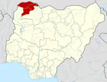 | |
This article is issued from Wikipedia. The text is licensed under Creative Commons - Attribution - Sharealike. Additional terms may apply for the media files.