Boduppal | |
|---|---|
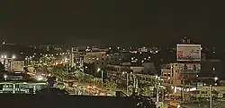
 City of Boduppal by night | |
 Boduppal Location in Telangana State, India  Boduppal Boduppal (India) | |
| Coordinates: 17°24′50″N 78°34′42″E / 17.4139°N 78.5783°E | |
| Country | |
| State | Telangana |
| District | Medchal-Malkajgiri |
| Mandal | Medipally |
| Metro | Hyderabad |
| Established | 2016 |
| Government | |
| • Type | Municipal Corporation |
| • Body | Boduppal Municipal Corporation |
| Area | |
| • Total | 20.53 km2 (7.93 sq mi) |
| Population (Census 2011) | |
| • Total | 48,225[1] |
| • Estimate (2020) | 135,000[1] |
| Languages | |
| • Official | Telugu |
| Time zone | UTC+5:30 (IST) |
| PIN Code | 500092 |
| Telephone code | 040 |
| Vehicle registration | TS 08 |
| Lok Sabha constituency | Malkajgiri |
| Vidhan Sabha constituency | Medchal |
| Website | boduppalmunicipality |
Boduppal is a satellite city of Hyderabad and a municipal corporation in Medchal–Malkajgiri District of Telangana, India.[1] It is administered by Boduppal Municipal Corporation. Located at the eastern end of Hyderabad City, it is spread between Nacharam-Mallapur Road and Warangal Highway NH 163. Due to its proximity to Secunderabad and Eastern IT/SEZ of Pocharam, it is emerging as a major residential location in Hyderabad.
Demographics
Telugu is the Local Language here. Total population of Boduppal (CT) is 43,692 according to census 2011. Among them Males are 22,255 and Females are 21,437 living in 2,666 Houses. Children's below 6 years are 5,163, Among them literate people are 32,038. All the numbers are according to 2011 census.
Boduppal Municipal Corporation
Boduppal is a city in Medchal – Malkajgiri district of the Indian state of Telangana. The Boduppal Municipality (Merging of Boduppal and Chengicherla Gram panchayats of Rangareddy) was formed in the year 2016 and was upgraded to Municipal Corporation on 23.07.2019 vide G.O. Ms. No. 211. The city spreads over an area of 20.53 Sq Km. Boduppal has been developing at a high growth rate due to its locational advantage with developments happening in and around like Pochram IT Park, proposed Rail Terminal at Cherlapally. Spiritual place like Yadagirigutta (Telangana Tirupati) which is located at distance of 51 km. Boduppal city is located at the intersection of longitude of 17.6297°, 78.4814° at a distance of 14 Km from Hyderabad MGBS Terminal and adjoining to Uppal Circle of GHMC limits. It is located in North East direction to State Capital of Telangana and at a distance of 14 km, 25 km from the Ghatkesar mandal headquarter and District headquarter located at Keesara respectively.
Transport
The Area is well connected by TSRTC to the rest of the City, having Bus Depo at Chengicherla and Uppal Depo at Boduppal Kaman. Nearest Railway station is Moula Ali, The other Railway station nearby is Cherlapally and Nearest Major Secunderabad Junction railway station. There is a proposal to upgrade Cherlapalli Railway Station,[2] as a Major Terminus to decongest traffic in Secunderabad Railway Station. A Fly-over is under construction across Boduppal, to handle the heavy traffic.
Government
Boduppal Municipal Corporation | |
|---|---|
| Type | |
| Type | |
| Leadership | |
Samala Buchi Reddy | |
Kotha Lakshmi Ravi Goud | |
| Structure | |
| Seats | 28 |
Political groups |
|
| Meeting place | |
| BMC Building | |
Boduppal Municipal Corporation administers the city of Boduppal. On 11 April 2016, the gram panchayats of Boduppal, Chengicherla were merged to form Boduppal Municipality. Boduppal Municipality is upgraded as Boduppal Municipal Corporation vide G.O.Ms.No.211, dt: 13.07.2019. Samala Buchi Reddy is elected as a First Mayor. Kotha Lakshmi Ravi Goud is Deputy Mayor.[3][4]
References
- 1 2 3 "Archived copy". Archived from the original on 25 May 2019. Retrieved 3 March 2020.
{{cite web}}: CS1 maint: archived copy as title (link) - ↑ Geetanath, V. (4 November 2015). "SCR plans mega terminal at Cherlapally". The Hindu. Retrieved 31 March 2017.
- ↑ "Five New Civic Bodies Carved out". The New Indian Express. 12 April 2016. Retrieved 14 June 2016.
- ↑ "Telangana to get seven new municipal corporations". 19 July 2019.