Bogusza | |
|---|---|
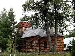
 Wooden Orthodox church in Bogusza | |
 Bogusza | |
| Coordinates: 49°34′N 20°53′E / 49.567°N 20.883°E | |
| Country | |
| Voivodeship | Lesser Poland |
| County | Nowy Sącz County |
| Gmina | Gmina Kamionka Wielka |
| Area | |
| • Total | 12.97 km2 (5.01 sq mi) |
| Population (2006) | |
| • Total | 610 |
| • Density | 47/km2 (120/sq mi) |
| Time zone | UTC+1 (CET) |
| • Summer (DST) | UTC+2 (CEST) |
| Postal code | 33-334 |
| Area code | +48 18 |
| Car plates | KNS |
Bogusza [bɔˈɡuʂa] Bogusha; Ukrainian: Богуша, Bohusha) is a village in southern Poland. It lies approximately 8 kilometres (5 mi) east of Kamionka Wielka, 15 km (9 mi) south-east of Nowy Sącz, and 88 km (55 mi) south-east of the regional capital Kraków.
Geography
Bogusza is located in a mountain valley in the Lesser Poland Voivodeship, along a stream named the Królówka, in the county of Nowy Sącz.
History
The town was essentially de-populated after World War II in Operation Vistula in 1947.
Monuments
The town is the site of the wooden church of St. Demetrius, built in 1858.
This article is issued from Wikipedia. The text is licensed under Creative Commons - Attribution - Sharealike. Additional terms may apply for the media files.