Bolton, Kansas | |
|---|---|
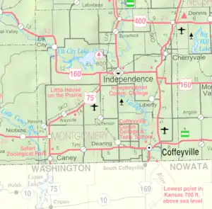 KDOT map of Montgomery County (legend) | |
 Bolton  Bolton | |
| Coordinates: 37°09′24″N 95°48′20″W / 37.15667°N 95.80556°W[1] | |
| Country | United States |
| State | Kansas |
| County | Montgomery |
| Founded | 1886 |
| Platted | 1886 |
| Elevation | 820 ft (250 m) |
| Time zone | UTC-6 (CST) |
| • Summer (DST) | UTC-5 (CDT) |
| Area code | 620 |
| FIPS code | 20-07900 |
| GNIS ID | 484441 [1] |
Bolton is an unincorporated community in Montgomery County, Kansas, United States.[1]
History
Bolton was laid out in 1886 when the railroad was extended to that point.[2]
References
- 1 2 3 4 U.S. Geological Survey Geographic Names Information System: Bolton, Kansas
- ↑ Duncan, L. Wallace (1903). History of Montgomery County, Kansas. Press of Iola Register. pp. 81.
Further reading
External links
Municipalities and communities of Montgomery County, Kansas, United States | ||
|---|---|---|
| Cities | 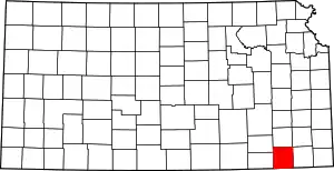 Map of Kansas highlighting Montgomery County | |
| Unincorporated communities | ||
| Ghost towns | ||
| Footnotes | †This community is designated a Census-Designated Place (CDP) by the United States Census Bureau. | |
This article is issued from Wikipedia. The text is licensed under Creative Commons - Attribution - Sharealike. Additional terms may apply for the media files.