Boluo
博罗县 Poklo; Polo | |
|---|---|
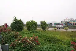 Guangzhou–Huizhou Expressway in the county | |
 Boluo in Huizhou | |
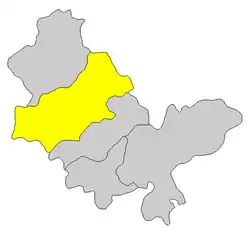
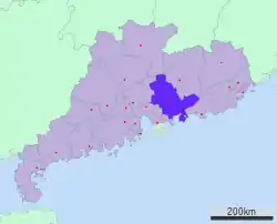 Huizhou in Guangdong | |
| Coordinates: 23°10′22″N 114°17′22″E / 23.1728°N 114.2895°E | |
| Country | People's Republic of China |
| Province | Guangdong |
| Prefecture-level city | Huizhou |
| County seat | Luoyang |
| Area | |
| • Total | 2,795 km2 (1,079 sq mi) |
| Population (2009) | |
| • Total | 813,730 |
| • Density | 290/km2 (750/sq mi) |
| Time zone | UTC+8 (China Standard) |
| Postal code | 5161XX |
| Area code | 0752 |
| Boluo County | |||||||||||
|---|---|---|---|---|---|---|---|---|---|---|---|
| Simplified Chinese | 博罗县 | ||||||||||
| Traditional Chinese | 博羅縣 | ||||||||||
| Jyutping | bok4 lo4-jyun6 | ||||||||||
| Hanyu Pinyin | Bóluó Xiàn | ||||||||||
| Postal | Poklo | ||||||||||
| |||||||||||
Boluo County (Chinese: 博罗县) is a county of east-central Guangdong province, People's Republic of China. It is under the administration of the prefecture-level city of Huizhou, and in 2009, had a population of 813,700 residing in an area of 2,795 km2 (1,079 sq mi). It borders Yuancheng District, Dongyuan and Zijin counties to the northeast, Huiyang and Huicheng Districts to the southeast, Dongguan to the south, Zengcheng to the west, and Longmen County to the northwest.
History
In Lüshi Chunqiu, the current Boluo used to be one of the many Yue states without a king before Qin dynasty.[1] The state's name was transliterated as 縛婁 (Simplified: 缚娄, Fuluo) in Chinese.[2] and it was located nearby Mount Luofu (羅浮山/罗浮山). 縛 (缚) or 浮 are the hanzi transliteration of the old Yue language's "people", while 羅 (罗) or 婁 means "cave". The current Boluo (博罗) is derived from the same old Yue word and therefore means "people in mountain".[3]
In 214 BCE after the unification of China by Qin, Fuluo County (傅羅縣) was established. Its name was altered to Boluo under the Emperor Wu of Jin's rule in 280 CE.
Administrative divisions
Boluo administers 17 towns:
| Name | Chinese (S) | Hanyu Pinyin | Population (2010)[4] | Area (km2) |
|---|---|---|---|---|
| Luoyang town | 罗阳镇 | Luōyáng Zhèn | 208,739 | 251.62 |
| Gongzhuang town | 公庄镇 | Gōngzhuāng Zhèn | 46,813 | 299.5 |
| Baitang town | 柏塘镇 | Bǎitáng Zhèn | 50,013 | 161.4 |
| Yangcun town | 杨村镇 | Yángcūn Zhèn | 41,958 | 120 |
| Mabei town | 麻陂镇 | Mábēi Zhèn | 21,690 | 58.6 |
| Shiba town | 石坝镇 | Shíbà Zhèn | 39,149 | 142 |
| Taimei town | 泰美镇 | Tàiměi Zhèn | 34,169 | 183.5 |
| Longxi town | 龙溪镇 | Lóngxī Zhèn | 88,964 | 115.84 |
| Yuanzhou town | 园洲镇 | Yuánzhōu Zhèn | 146,053 | 110 |
| Shiwan town | 石湾镇 | Shíwān Zhèn | 122,802 | 83 |
| Longhua town | 龙华镇 | Lónghuá Zhèn | 26,009 | 62 |
| Futian town | 福田镇 | Fútián Zhèn | 38,286 | 86.7 |
| Changning town | 长宁镇 | Chángníng Zhèn | 39,983 | 117 |
| Huzhen town | 湖镇镇 | Húzhèn Zhèn | 56,551 | 117.3 |
| Yangqiao town | 杨侨镇 | Yángqiáo Zhèn | 29,868 | 89 |
| Guanyinge town | 观音阁镇 | Guānyīngé Zhèn | 17,309 | 143 |
| Henghe town | 横河镇 | Hénghé Zhèn | 21,421 | 232.88 |
Economy
Boluo County is said to be the home to the country's largest farm for raising the rare "Golden coin turtle" Cuora trifasciata.[5]
Transport
Guangzhou–Huizhou and Huizhou–Heyuan Expressway (惠河高速公路) intersect within the county, and China National Highways 205 and 324 as well as the Beijing–Kowloon and Guangzhou–Meizhou–Shantou railways traverse the entire county.
Climate
| Climate data for Boluo (1991–2020 normals, extremes 1981–2010) | |||||||||||||
|---|---|---|---|---|---|---|---|---|---|---|---|---|---|
| Month | Jan | Feb | Mar | Apr | May | Jun | Jul | Aug | Sep | Oct | Nov | Dec | Year |
| Record high °C (°F) | 28.6 (83.5) |
31.3 (88.3) |
33.2 (91.8) |
34.3 (93.7) |
35.8 (96.4) |
37.9 (100.2) |
39.0 (102.2) |
38.0 (100.4) |
37.7 (99.9) |
36.3 (97.3) |
33.8 (92.8) |
30.2 (86.4) |
39.0 (102.2) |
| Mean daily maximum °C (°F) | 19.6 (67.3) |
20.8 (69.4) |
23.3 (73.9) |
27.0 (80.6) |
30.3 (86.5) |
32.1 (89.8) |
33.5 (92.3) |
33.3 (91.9) |
32.3 (90.1) |
29.7 (85.5) |
25.9 (78.6) |
21.3 (70.3) |
27.4 (81.4) |
| Daily mean °C (°F) | 14.3 (57.7) |
16.0 (60.8) |
18.8 (65.8) |
22.7 (72.9) |
26.0 (78.8) |
27.9 (82.2) |
28.9 (84.0) |
28.6 (83.5) |
27.6 (81.7) |
24.7 (76.5) |
20.4 (68.7) |
15.7 (60.3) |
22.6 (72.7) |
| Mean daily minimum °C (°F) | 10.9 (51.6) |
12.8 (55.0) |
15.8 (60.4) |
19.8 (67.6) |
23.0 (73.4) |
25.1 (77.2) |
25.8 (78.4) |
25.6 (78.1) |
24.4 (75.9) |
21.1 (70.0) |
16.8 (62.2) |
12.1 (53.8) |
19.4 (67.0) |
| Record low °C (°F) | 0.1 (32.2) |
0.9 (33.6) |
2.1 (35.8) |
9.3 (48.7) |
15.5 (59.9) |
18.4 (65.1) |
20.2 (68.4) |
22.3 (72.1) |
16.9 (62.4) |
10.0 (50.0) |
4.9 (40.8) |
−0.1 (31.8) |
−0.1 (31.8) |
| Average precipitation mm (inches) | 47.7 (1.88) |
54.9 (2.16) |
104.2 (4.10) |
208.1 (8.19) |
266.0 (10.47) |
413.9 (16.30) |
258.4 (10.17) |
314.3 (12.37) |
167.5 (6.59) |
41.9 (1.65) |
30.1 (1.19) |
35.4 (1.39) |
1,942.4 (76.46) |
| Average precipitation days (≥ 0.1 mm) | 6.4 | 9.1 | 12.6 | 14.3 | 17.1 | 19.4 | 16.5 | 17.2 | 12.1 | 4.7 | 4.8 | 5.5 | 139.7 |
| Average relative humidity (%) | 73 | 76 | 79 | 81 | 81 | 83 | 80 | 81 | 77 | 71 | 71 | 70 | 77 |
| Mean monthly sunshine hours | 130.4 | 94.2 | 84.7 | 90.7 | 123.6 | 143.8 | 198.3 | 182.3 | 187.9 | 196.3 | 166.9 | 149.9 | 1,749 |
| Percent possible sunshine | 39 | 30 | 23 | 24 | 30 | 34 | 46 | 44 | 50 | 57 | 51 | 47 | 40 |
| Source: China Meteorological Administration[6][7] | |||||||||||||
Notes
- ↑ 资讯 : 人民日报:站在缚娄古国遗址上. China Cultural Artifact Protection Foundation (中国文物保护基金会). 2007-08-08. Archived from the original on July 4, 2011. Retrieved April 4, 2010.
- ↑ 谭其骧 (1996). 中国历史地图集(第一册):先秦. 中国地图出版社. pp. 45–46.
- ↑ 司徒尚纪 (1998). 广东政区体系——历史·现实·改革. 中山大学出版社. p. 20. ISBN 9787306014184.
- ↑ Census Office of the State Council of the People's Republic of China; Population and Employment Statistics Division of the National Bureau of Statistics of the People's Republic of China (2012). 中国2010人口普查分乡、镇、街道资料 (1 ed.). Beijing: China Statistics Print. ISBN 978-7-5037-6660-2.
- ↑ 财富人物:金钱龟"中国第一人" 2007-09-24
- ↑ 中国气象数据网 – WeatherBk Data (in Simplified Chinese). China Meteorological Administration. Retrieved 28 May 2023.
- ↑ 中国气象数据网 (in Simplified Chinese). China Meteorological Administration. Retrieved 28 May 2023.
| Sub-provincial cities |
| ||||||||||||||||||||||||||||||||||||||||||||||||||||||||||||||||||||
|---|---|---|---|---|---|---|---|---|---|---|---|---|---|---|---|---|---|---|---|---|---|---|---|---|---|---|---|---|---|---|---|---|---|---|---|---|---|---|---|---|---|---|---|---|---|---|---|---|---|---|---|---|---|---|---|---|---|---|---|---|---|---|---|---|---|---|---|---|---|
| Prefecture-level cities |
| ||||||||||||||||||||||||||||||||||||||||||||||||||||||||||||||||||||