| Boyertown Area School District | |
|---|---|
 | |
| Address | |
911 Montgomery Avenue
Boyertown , Berks County, Montgomery County, Pennsylvania, 19512United States | |
| District information | |
| Type | Public |
| Motto | "To enable all students to succeed in a changing world!" |
| Established | 1953 |
| Students and staff | |
| District mascot | Bears |
| Other information | |
| Website | www |

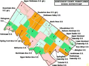
The Boyertown Area School District is a large public school district which covers portions of Berks and Montgomery Counties in southeastern Pennsylvania.[1] When the Boyertown Area School District was formed in 1953 it was one of the largest in the state, encompassing 100 square miles (260 km2). In Berks County it covers the Boroughs of Bally, Bechtelsville and Boyertown and Colebrookdale Township, Douglass Township, Earl Township and Washington Township. In Montgomery County it covers Douglass Township, New Hanover Township and Upper Frederick Township.
According to 2006 local census data, Boyertown Area School District serves a resident population of 34,803. In 2009, the district residents’ per capita income was $22,792, while the median family income was $61,247.[2] In the Commonwealth, the median family income was $49,501[3] and the United States median family income was $49,445, in 2010.[4]
Schools
The district operates six Elementary Schools, two Middle Schools (6th-8th) and one Senior High School (9th-12th).
- Elementary schools
- Boyertown Elementary School
- Colebrookdale Elementary School
- Earl Elementary School
- Gilbertsville Elementary School
- New Hanover-Upper Frederick Elementary School
- Washington Elementary School
- Secondary schools
- Boyertown Area Middle School-East Center
- Boyertown Area Middle School-West Center
- Boyertown Area Senior High School
Extracurriculars
The district offers a variety of clubs, activities and sports.
Sports
The district funds:
|
|
- Junior High School Sports
|
|
According to PIAA directory July 2012 [5]
References
- ↑ "District Overview / Welcome".
- ↑ US Census Bureau, American Fact Finder, 2009
- ↑ US Census Bureau (2010). "American Fact Finder, State and County quick facts". Archived from the original on 2014-10-06. Retrieved 2013-03-09.
- ↑ US Census Bureau (September 2011). "Income, Poverty, and Health Insurance Coverage in the United States: 2010" (PDF).
- ↑ Pennsylvania Interscholastic Athletics Association (2012). "PIAA School Directory".