53°24′27.5″N 2°58′8.2″W / 53.407639°N 2.968944°W
 | |
| Formation | 1969 |
|---|---|
| Location | |
Head of BODC | Dr Helen Snaith |
Parent organization | National Oceanography Centre (NOC) |
| Website | BODC.ac.uk |
The British Oceanographic Data Centre (BODC) is a national facility for looking after and distributing data about the marine environment. BODC is the designated marine science data centre for the United Kingdom and part of the National Oceanography Centre (NOC)[1] — primarily at its facility in Liverpool, with small number of its staff in Southampton. The centre provides a resource for science, education and industry, as well as the general public.


History
In 1969, the Natural Environment Research Council created the British Oceanographic Data Service (BODS).[2][3] Located at the National Institute of Oceanography in Wormley, Surrey, its purpose was to:
- Act as the UK's national oceanographic data centre
- Participate in the international exchange of data as part of the Intergovernmental Oceanographic Commission (IOC) network of national data centres
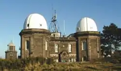
In 1975, BODS was transferred to Bidston Observatory on the Wirral, near Liverpool, as part of the newly formed Institute of Oceanographic Sciences. The following year BODS became the Marine Information and Advisory Service (MIAS). Its primary activity was to manage the data collected from weather ships, oil rigs, and data buoys. The data banking component of MIAS was restructured to form BODC in April 1989.[2][4]
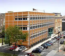
In December 2004, BODC moved to the purpose-built Joseph Proudman Building on the campus of the University of Liverpool. A smaller number of its staff are based in the National Oceanography Centre (NOC), Southampton.
National role
BODC is one of five designated data centers that make up the NERC Environmental Data Service and manage NERC's environmental data.[5] The BODC has a number of national roles and responsibilities:
- Performing data management for NERC-funded marine projects
- Maintaining and developing its archive of marine data, the National Oceanographic Database (NODB)
- Managing, checking and archiving data from tide gauges around the UK coast for the National Tide Gauge Network, which aims to obtain high quality tidal information and to provide warning of possible flooding of coastal areas around the British Isles. This is part of the National Tidal & Sea Level Facility (NTSLF)
- Hosting the Marine Environmental Data and Information Network
- Working in partnership with other NERC marine research centres:
- British Antarctic Survey (BAS)
- National Oceanography Centre (NOC), Liverpool, formerly Proudman Oceanographic Laboratory (POL)
- National Oceanography Centre (NOC), Southampton
- Plymouth Marine Laboratory (PML)
- Scottish Association for Marine Science (SAMS)
- Sea Mammal Research Unit (SMRU)
International role
BODC's international roles and responsibilities include:
- Contributing to the International Council for the Exploration of the Sea (ICES) Marine Data Management
- Creating, maintaining and publishing the General Bathymetric Chart of the Oceans (GEBCO) Digital Atlas[6]
- BODC is one of over 60 national oceanographic data centres that form part of the IOC International Oceanographic Data and Information Exchange (IODE)
References
- ↑ jnally (22 June 2023). "Global seafloor success: 25% has now been mapped". Spatial Source. Retrieved 14 January 2024.
- 1 2 Ball, Alexander (2009), Scientific Data Application Profile Scoping Study Report (PDF), p. 5
- ↑ Buck, Justin; Ayliffe, James; Bradshaw, Elizabeth; Gaffney, Sean; Houseago-Stokes, Richenda; Moncoiffé, Gwenaëlle; Snaith, Helen (4 January 2021). "More Than Just DOIs, How to Pragmatically Make 50 Years of Diverse Data Centre Holdings and Services Citable, The Perspective and Aspirations of the British Oceanographic Data Centre". Authorea. doi:10.1002/essoar.10505542.1. Retrieved 14 January 2024.
- ↑ "The race to map the gaps - Maritime Foundation". www.maritimefoundation.uk. 6 November 2020. Retrieved 14 January 2024.
- ↑ "Research expedition to assess the recovery of Scottish coral reef | University of Southampton". www.southampton.ac.uk. Retrieved 14 January 2024.
- ↑ Showstack, Randy (9 December 2019). "Momentum Grows for Mapping the Seafloor". Eos. Retrieved 14 January 2024.