| Burning Palms New South Wales | |
|---|---|
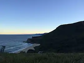
 Southwestern view of the beach from Burgh Ridge Track | |
 Burning Palms | |
| Coordinates | 34°11′S 151°03′E / 34.183°S 151.050°E |
| Postcode(s) | 2508 |
| LGA(s) | City of Wollongong |
| State electorate(s) | Heathcote |
| Federal division(s) | Cunningham |
Wikimedia Commons has media related to Burning Palms, New South Wales.
Burning Palms is an unbounded neighbourhood within the locality of Lilyvale and a beach in the Royal National Park, Wollongong, south of Sydney, New South Wales, Australia.[1] It has a surf club and a local cabin community, and is a popular day-walk destination, along with the 'figure-8' rock pools on the rock shelf to the beach's south.
It is accessed via a very steep, moderately difficult walk down (and up) the mountain through forest and grass plains. It is located in the area known as the Garawarra.[2]
Together with Little Garie and Era, the neighbourhood was added to the New South Wales State Heritage Register on 27 April 2012 as part of the Royal National Park Coastal Cabin Communities.[3]
Notes
- ↑ "Burning Palms Beach[?]". The Sydney Morning Herald. National Library of Australia. 16 October 1935. p. 16. Retrieved 20 June 2011.
- ↑ Dunphy, Myles, 1891-1985 (1935). * From Garie to Burning Palms, from Governor Game Lookout to the sea. In Sketch map of part of Garawarra. Myles J. Dunphy, [Sydney] http://trove.nla.gov.au/work/36576983
- ↑ "Royal National Park Coastal Cabin Communities". New South Wales State Heritage Register. Department of Planning & Environment. H01878. Retrieved 2 June 2018.
 Text is licensed by State of New South Wales (Department of Planning and Environment) under CC-BY 4.0 licence.
This article is issued from Wikipedia. The text is licensed under Creative Commons - Attribution - Sharealike. Additional terms may apply for the media files.