Bushwood is an area in the north of Leytonstone in East London; determined by the curved boundary of the road called Bushwood along the edge of Wanstead Flats, Lister Road to the south and High Road, Leytonstone to the west.[1][2] The area has the Browning Road Conservation Area, that contains what remains of the historic hamlet of Leyton-atte-stone.
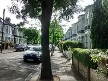
The area has many tree-lined streets with Victorian and Edwardian houses, which continue to attract professionals and young families.[3][4] The area is popular for its proximity to Wanstead Flats and Wanstead Park, quick access to restaurants, cafés and shops,[5][6] and transport links into central London via the Central Line.[7] Bushwood has a residents' association, covering the approximately 1500 houses in the area.[8]
History
It is named after the ancient woodland of Bush Wood, which creates part of the north-east border of the area.
Notable features
Browning Road Conservation Area
Bushwood includes The Browning Road Conservation Area consists of terraces of ‘Georgian’ cottages. These were preserved as a reminder of their special historic and architectural interest by Waltham Forest Council in March 1973.[9]
The North Star
The North Star Public House is situated on Browning Road[10] in the heart of the Conservation Area. Originally two cottages converted into a Public House it is thought that the name of this establishment comes as a direct result of a sailing voyage taken by the founder of the North Star, Frederick Wildsmith which involved his returning from India with a monkey[11] and so fond was he of this memory, he decided to name the pub after the twin-masted, 253 ton Brigantine in which he had travelled. The North Star's first mention is in the 1858 Rate book with Frederick listed as a ‘beer retailer’ in the 1891 census.
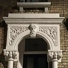
Victorian keystones

Many Victorian houses in Bushwood have decorative keystones above their entrances in the form of faces. Mainly found in Leyspring, Leybourne, Barclay and Woodville Roads, the use of these elements was influenced by the Neoclassical architecture introduced by Romanticism in the early Victorian period (mid 1800s).
Henry Reynolds Park
At the northernmost part of Bushwood, is Henry Reynolds Park which includes a playground for children of all ages and basketball shooting practice area.[12] Originally a gravel pit that became Green Man Pond; it was drained in the 1970s to form the present day park with its sunken gardens.
Leytonstone Mosque
Bushwood is the location of Leytonstone Mosque.
Ferndale area
Ferndale is an area of streets that adjoins the south of Bushwood; covering Davies Lane, Cotton Close, Ferndale Road, Malvern Road and Montague Road. While not formally part of Bushwood, Ferndale has a similar mix of housing and gentrification.[13] It also has a residents' association for the area, modelled on the sister Bushwood association.[14][15]
Gallery
 Sculpture by Stephen Duncan in Bushwood area of Leytonstone
 Row of Victorian houses in Bushwood area of Leytonstone
References
- ↑ "The Guardian - Let's Move To Leytonstone". 21 September 2018.
- ↑ "The Emmerson Papers - Cut Out & Keep Guide To Leytonstone". 18 February 2015.
- ↑ "Four London areas for £250k budgets with future price-growth potential". Homes and Property. 2017-01-10. Retrieved 2017-04-29.
- ↑ "Up And Coming Areas In The UK 2017".
- ↑ "Evening Standard Article on Neighbouring Wanstead". Evening Standard. Retrieved 2017-04-28.
- ↑ "Timeout - Guide To Leytonstone 2015". 15 August 2015.
- ↑ "Where To Live Along The Central Line For Speedy Commute, Value For Money and A Great Social Life". Evening Standard Homes And Property. 2017-06-21.
- ↑ "Bushwood Area Residents Association (BARA)". Retrieved 26 July 2021.
- ↑ "Waltham Forest Gov - Browning Road Appraisal Management" (PDF). Retrieved 26 July 2021.
- ↑ "Article in Leytonstoner on Browning Road in Bushwood Area of Leytonstone". Leytonstoner. 2017-04-13. Retrieved 2017-04-28.
- ↑ "BARA - Browning Road Conservation Area" (PDF). Retrieved 24 July 2021.
- ↑ "Henry Reynolds Park Re-opens".
- ↑ "Street List - Ferndale Road in Leytonstone". Retrieved 26 July 2021.
- ↑ "Ferndale Area Residents Association (FARA)". Retrieved 26 July 2021.
- ↑ "Leytonstone Areas". Retrieved 26 July 2021.