Caborca | |
|---|---|
 Seal | |
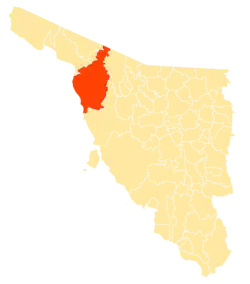 Location of the municipality in Sonora. | |
| Country | |
| State | Sonora |
| Municipal Seat | Caborca |
| Area | |
| • Total | 10,721.84 km2 (4,139.73 sq mi) |
| Population (2010) | |
| • Total | 81,309 |
| • Density | 7.58/km2 (19.6/sq mi) |
| Time zone | UTC-7 (Mountain Standard Time) |
| • Summer (DST) | UTC-7 (No DST) |
Caborca is a municipality in the Mexican state of Sonora in northwestern Mexico.[1]
The area of the municipality is 10,721.84 km2, which is 5.78 percent of the state total.
Towns and villages
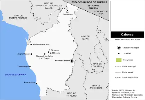
Major localities
There are 341 localities in Caborca Municipality, the largest of which are:
| Name | 2010 Census Population |
|---|---|
| Caborca | 59,922 |
| Plutarco Elías Calles (La Y Griega) | 3,725 |
| El Diamante (La Retranca) | 3,374 |
| El Coyote | 1,337 |
| Siempre Viva | 815 |
| Poblado San Felipe | 767 |
| Desemboque | 733 |
| Álvaro Obregó | 707 |
| Adolfo Oribe de Alva | 659 |
| La Almita | 644 |
| Último Esfuerzo | 592 |
| La Alameda | 546 |
| José María Morelos | 490 |
| Total Municipality | 81,309 |
Other localities include: Josefa Ortiz de Domínguez, 15 de Septiembre, Santa Eduwiges, Viñedo Viva, Ures, Rodolfo Campodónico, Poblado Cerro Blanco, Puerto Lobos, San Francisquito.
References
- ↑ "-". Enciclopedia de los Municipios de México. Instituto Nacional para el Federalismo y el Desarrollo Municipal. Archived from the original on July 31, 2012. Retrieved January 4, 2010.
Places adjacent to Caborca Municipality | |
|---|---|

30°47′03″N 112°31′05″W / 30.7841°N 112.5180°W
Wikimedia Commons has media related to Caborca Municipality.
This article is issued from Wikipedia. The text is licensed under Creative Commons - Attribution - Sharealike. Additional terms may apply for the media files.