49°57′22″N 1°46′2″E / 49.95611°N 1.76722°E
Oisemont | |
|---|---|
Former canton | |
| Country | France |
| Region | Hauts-de-France |
| Department | Somme |
| No. of communes | 31 |
| Disbanded | 2015 |
| Seat | Oisemont |
| Area | 143.83 km2 (55.53 sq mi) |
| Population (2012) | 6,183 |
| • Density | 43/km2 (110/sq mi) |
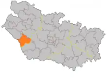
The Canton of Oisemont is a former canton in the department of the Somme and in the Picardy region of northern France. It was disbanded following the French canton reorganisation in March 2015. It consisted of 31 communes,[1] which joined the canton of Poix-de-Picardie in 2015.[2] It had 6,183 inhabitants (2012).[1]
Geography
The canton is organised around the commune of Oisemont in the arrondissement of Abbeville (arrondissement of Amiens before 2009). The altitude varies from 48m at Heucourt-Croquoison to 204m at Neuville-Coppegueule for an average of 118m. The canton's economy is almost entirely agricultural, only the chef-lieu having a population in excess of 1000.
The canton comprised 31 communes:[1]
- Andainville
- Aumâtre
- Avesnes-Chaussoy
- Bermesnil
- Cannessières
- Épaumesnil
- Étréjust
- Fontaine-le-Sec
- Forceville-en-Vimeu
- Foucaucourt-Hors-Nesle
- Fresnes-Tilloloy
- Fresneville
- Fresnoy-Andainville
- Frettecuisse
- Heucourt-Croquoison
- Inval-Boiron
- Lignières-en-Vimeu
- Le Mazis
- Mouflières
- Nesle-l'Hôpital
- Neslette
- Neuville-au-Bois
- Neuville-Coppegueule
- Oisemont
- Saint-Aubin-Rivière
- Saint-Léger-sur-Bresle
- Saint-Maulvis
- Senarpont
- Vergies
- Villeroy
- Woirel
Population
| 1962 | 1968 | 1975 | 1982 | 1990 | 1999 |
|---|---|---|---|---|---|
| 5753 | 6347 | 6340 | 6232 | 6172 | 5957 |
| Census count starting from 1962 : Population without double counting | |||||
See also
References
External links
- Oisemont, Trésor des régions (in French)
This article is issued from Wikipedia. The text is licensed under Creative Commons - Attribution - Sharealike. Additional terms may apply for the media files.