 | |
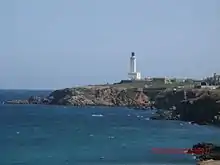
| Location | Cap Caxine, Hammamet, Algeria |
|---|---|
| Coordinates | 36°48′46″N 2°57′15″E / 36.812872°N 2.954119°E |
| Tower | |
| Constructed | 1868 |
| Construction | masonry tower |
| Height | 33 m (108 ft) |
| Shape | quadrangular tower with balcony and lantern atop a 2-storey keeper’s house[1][2][3] |
| Markings | white tower, blue lantern |
| Operator | Office Nationale de Signalisation Maritime |
| Light | |
| Focal height | 64 m (210 ft) |
| Range | 30 nmi (56 km; 35 mi) |
| Characteristic | Fl W 5s |
See also
References
- ↑ "Cap Caxine". Office Nationale de Signalisation Maritime. Ministere des Travaux Publics. Retrieved 28 April 2017.
- ↑ List of Lights, Pub. 113: The West Coasts of Europe and Africa, the Mediterranean Sea, Black Sea and Azovskoye More (Sea of Azov) (PDF). List of Lights. United States National Geospatial-Intelligence Agency. 2015.
- ↑ Rowlett, Russ. "Lighthouses of Western Algeria". The Lighthouse Directory. University of North Carolina at Chapel Hill. Retrieved 28 April 2017.
- ↑ "Cap Caxine, Algeria Map". Mapcarta. Retrieved 18 June 2010.
External links
- Cap Caxine Ministere des Travaux Public
Wikimedia Commons has media related to Cap Caxine Lighthouse.
36°48′47″N 2°57′09″E / 36.81306°N 2.95250°E
This article is issued from Wikipedia. The text is licensed under Creative Commons - Attribution - Sharealike. Additional terms may apply for the media files.