Cape Christiansen
Kap Christiansen | |
|---|---|
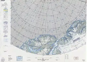 Map of part of Ellesmere Island and far Northern Greenland | |
 Cape Christiansen | |
| Coordinates: 83°25′N 39°40′W / 83.417°N 39.667°W | |
| Location | Peary Land, Greenland |
| Offshore water bodies | Conger Sound Lincoln Sea Weyprecht Fjord |
Cape Christiansen (Danish: Kap Christiansen) is a headland in North Greenland. Administratively it belongs to the Northeast Greenland National Park.[1]
Cape Christiansen was named after Frederick Thorlip Christiansen (1846 – 1884), Inughuit dogsled driver and guide of the Lady Franklin Bay Expedition who died of starvation on April 5, 1884 at Camp Clay.[2]
Geography
Cape Christiansen is a headland located at the northern end of Lockwood Island, on the western side of the mouth of Conger Sound and on the eastern side of Weyprecht Fjord.[3][4][5] Near the point there is a cairn that was built by Lieutenant Lockwood in 1882. The cairn was surveyed by Robert Peary in 1900 and by Lauge Koch in 1921.[4]
Cape Kane is the headland on the eastern side of Conger Sound, at the northern end of Roosevelt Land.[3][1]
See also
References
- 1 2 Nunat Aqqi; Stednavne
- ↑ Meet the Explorers — Fort Conger
- 1 2 Prostar Sailing Directions 2005 Greenland and Iceland Enroute, p. 95
- 1 2 Greenland Pilot
- ↑ Geographical Items on North Greenland - Encyclopedia Arctica 14