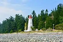
 Cape Mudge Lighthouse | |
| Location | Quadra Island British Columbia Canada |
|---|---|
| Coordinates | 49°59′54.8″N 125°11′43.9″W / 49.998556°N 125.195528°W |
| Tower | |
| Constructed | 1898 (first) |
| Construction | concrete tower |
| Height | 12 metres (39 ft) |
| Shape | octagonal tower with balcony and lantern |
| Markings | white tower, red balcony and lantern |
| Operator | Canadian Coast Guard |
| Heritage | heritage lighthouse |
| Light | |
| First lit | 1916 (current) |
| Focal height | 17.5 metres (57 ft) |
| Range | 13 nmi (24 km; 15 mi) |
| Characteristic | F WR |
Cape Mudge Lighthouse is located on Quadra Island which is off Campbell River, on the east coast of Vancouver Island, British Columbia, Canada.[1]
Cape Mudge was named by Captain George Vancouver in 1792 after Zachary Mudge, who had served on HMS Discovery, and in 1796 on HMS Providence in this area.[2]: 181
Built in 1898, the original lighthouse was a wooden, two-storey building topped with a lantern on the roof. It later served as lighthouse assistant keeper's residence after the current lighthouse opened in 1916 and was demolished after 1949.[3]
From 1936 to 1985, the Cape Mudge Lighthouse was part of the British Columbia Shore Station Oceanographic Program, collecting coastal water temperature and salinity measurements for the Department of Fisheries and Oceans everyday for 49 years.[4]
See also
References
- ↑ Rowlett, Russ. "Lighthouses of Canada: Southern British Columbia". The Lighthouse Directory. University of North Carolina at Chapel Hill. Retrieved 5 November 2014.
- ↑ Akrigg, G.P.V.; Akrigg, Helen B. (1986), British Columbia Place Names (3rd, 1997 ed.), Vancouver: UBC Press, ISBN 0-7748-0636-2
- ↑ "Cape Mudge (Quadra Island) Lighthouse".
- ↑ "British Columbia Lightstation Sea-Surface Temperature and Salinity Data (Pacific), 1914-present - Open Government Portal". open.canada.ca. Treasury Board of Canada. Retrieved 2021-02-11.
External links
- Aids to Navigation Canadian Coast Guard