Cartaojal | |
|---|---|
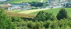
 View of Cartaojal | |
 Flag  Seal | |
 Cartaojal  Cartaojal | |
| Coordinates: 37°06′30″N 04°30′45″W / 37.10833°N 4.51250°W | |
| Country | |
| Autonomous community | |
| Province | Málaga |
| Municipality | Antequera |
| Government | |
| • Mayor | José A. Campos |
| Elevation | 537 m (1,762 ft) |
| Population (2022) | |
| • Total | 1,199 |
| Time zone | UTC+1 (CET) |
| • Summer (DST) | UTC+2 (CEST) |
| Postal code | 29250 |
Cartaojal is a village in Antequera, Málaga, Andalusia, Spain. According to the 2022 census, the village has an estimated population of about 1,199.[1]
Geography
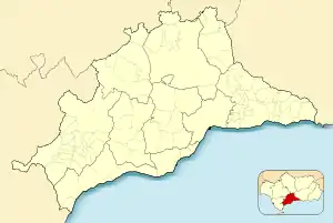
Cartaojal is located at the eastern edge of Antequera. It shares border with Cañadas de Pareja to the north, Archidona to the east, Los Llanos to the south, and Mollina to the west. The village has an average elevation of 537 meters above the sea level.[2]
Demographics
According to the Instituto Nacional de Estadística, as of 2022 Cartaojal has a total population of 1,199, out of which 599 are male inhabitants and 600 are female inhabitants.[1]
Galleries
 Snow day on February 28, 2013
 Romería de Cartaojal Festival
 Multi-use public building in Cartaojal
 Local church
See also
References
- 1 2 "Population of Province and Municipality". National Statistics Institute. Retrieved 2023-03-24.
- ↑ "Cartaojal topographic map, elevation, terrain". Topographic maps. Retrieved 2023-03-24.
This article is issued from Wikipedia. The text is licensed under Creative Commons - Attribution - Sharealike. Additional terms may apply for the media files.