| Cerquilla River | |
|---|---|
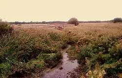
 The Cerquilla River with a dilapidated bridge in the background, near the Windmill of the Aldehuela, in the municipality of Frumales | |
| Location | |
| Autonomous com. | |
| Province of Segovia | |
| Physical characteristics | |
| Mouth | Cega River |
• coordinates | 41°22′29″N 4°20′08″W / 41.37462°N 4.33565°W |
• elevation | 900 m |
| Length | 30 km |
The Cerquilla River is a right tributary of the Cega River in Spain. Its approximately 30 km of route runs through the north of the province of Segovia.
Route
The Cerquilla River begins in the municipality of Fuentepiñel, then later crosses the south of the municipality of Fuentesaúco de Fuentidueña, separates Cozuelos de Fuentidueña from Olombrada, then enters the municipality of Perosillo, where it meets with the Cagarroñas stream. After meeting with Cagarroñas, it crosses the urban area of Frumales and, approaching the last kilometers of its route, enters Cuéllar through Dehesa Mayor, where it meets with the Mondajos stream and begins to mark the border of the Mar de Pinares. In the La Vega area, next to the Pradillos stream, it borders the El Espadañal area.[1]
References
- ↑ "Naturaleza > Espacios Naturales > El Espadañal". Archived from the original on 2009-09-03. Retrieved 2020-08-21.