| Chéran | |
|---|---|
.JPG.webp) The Chéran at Lescheraines | |
  | |
| Location | |
| Country | France |
| Physical characteristics | |
| Source | |
| • location | Verrens-Arvey |
| • coordinates | 45°40′23″N 06°15′32″E / 45.67306°N 6.25889°E |
| • elevation | 1,400 m (4,600 ft) |
| Mouth | |
• location | Fier |
• coordinates | 45°53′09″N 05°56′01″E / 45.88583°N 5.93361°E |
• elevation | 308 m (1,010 ft) |
| Length | 53.8 km (33.4 mi) |
| Basin size | 350 km2 (140 sq mi) |
| Discharge | |
| • average | 7.8 m3/s (280 cu ft/s) |
| Basin features | |
| Progression | Fier→ Rhône→ Mediterranean Sea |
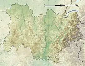
The Chéran (French pronunciation: [ʃeʁɑ̃]) is a 53.8 km (33.4 mi) long river in the Savoie and Haute-Savoie départements, eastern France.[1] Its source is at Verrens-Arvey, in the massif des Bauges. It flows generally northwest. It is a left tributary of the Fier into which it flows at Rumilly.
Départements and communes along its course
This list is ordered from source to mouth:
- Savoie: Verrens-Arvey, Cléry, Jarsy, École, La Compôte, Le Châtelard, La Motte-en-Bauges, Lescheraines, Arith, Bellecombe-en-Bauges
- Haute-Savoie: Allèves, Cusy, Gruffy, Héry-sur-Alby, Mûres, Alby-sur-Chéran, Saint-Sylvestre, Marigny-Saint-Marcel, Boussy, Rumilly, Sales
References
Wikimedia Commons has media related to Chéran.
This article is issued from Wikipedia. The text is licensed under Creative Commons - Attribution - Sharealike. Additional terms may apply for the media files.