Chơn Thành
Thị xã Chơn Thành | |
|---|---|
| Chơn Thành town | |
 | |
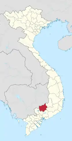
Interactive map outlining Chơn Thành | |
| Country | |
| Region | Southeast |
| Province | Bình Phước |
| Seat | Hưng Long |
| Area | |
| • Town (Class-4) | 150.71 sq mi (390.34 km2) |
| • Urban | 86.51 sq mi (224.06 km2) |
| Population (2021) | |
| • Town (Class-4) | 121,083 |
| • Density | 800/sq mi (310/km2) |
| • Urban | 94,820 |
| • Urban density | 1,100/sq mi (420/km2) |
| Time zone | UTC+07:00 (Indochina Time) |
Chơn Thành is a town of Bình Phước province, in the region of Vietnam. As of 2021 the town had a population of 121,083.[1] The town covers an area of 390.34 km². The town seat lies at Hưng Long ward.[1]
Chơn Thành was formerly a rural district of Bình Phước province. It gained town status on August 11, 2022.[2]
The stream Ông Thành was the location of the Battle of Ông Thành in the Vietnam War.
References
- 1 2 "Districts of Vietnam". Statoids. Retrieved March 20, 2009.
- ↑ "Establishment of Binh Phu township (Tien Giang province) and Chon Thanh town (Binh Phuoc province)".
11°25′45″N 106°39′26″E / 11.42917°N 106.65722°E
| Provincial cities |
|  |
|---|---|---|
| District-level towns | ||
| Districts | ||
| Ho Chi Minh City |
|  |
|---|---|---|
| Bà Rịa–Vũng Tàu province | ||
| Bình Dương province |
| |
| Bình Phước province |
| |
| Đồng Nai province | ||
| Tây Ninh province |
| |
※ denotes provincial seat | ||
This article is issued from Wikipedia. The text is licensed under Creative Commons - Attribution - Sharealike. Additional terms may apply for the media files.