| Administrative Units of Vietnam |
|---|
| First-level |
| Second-level |
| Third-level |
| Fourth-level (unofficial) |
|

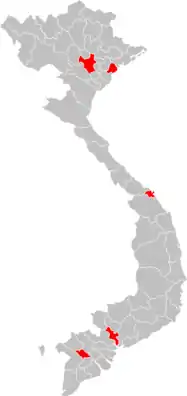
Map of Centrally governed cities in Vietnam
On the first tier, Vietnam is divided into 58 provinces (Vietnamese: tỉnh) and 5 municipalities (Vietnamese: thành phố trực thuộc trung ương). Municipalities are the highest-ranked cities in Vietnam.[1] Municipalities are centrally-controlled cities and have special status equal to the province.
The municipalities are divided into urban districts (quận), municipal cities (thành phố thuộc thành phố trực thuộc trung ương), towns (thị xã) and rural districts (huyện) as the second-tier units. At the third tier, urban districts are divided into wards (phường), towns are divided into wards (phường) and communes (xã), while rural districts are divided into townships (thị trấn) and communes (xã).
 |
|---|
|
|
Current municipalities
| Municipality | Vietnamese name | Class | Region | Established | Population (2019 census) |
Population density | Area (km2) |
Divisions |
|---|---|---|---|---|---|---|---|---|
| Hanoi | Hà Nội | Special | Red River Delta | 1945 | 8,053,663 | 2,300 | 3,344.7 | List |
| Ho Chi Minh City | Thành phố Hồ Chí Minh | Special | Southeast | 1955 | 8,993,082 | 4,100 | 2,095 | List |
| Cần Thơ | Cần Thơ | I | Mekong Delta | 2003 | 1,235,171 | 890 | 1,389.6 | List |
| Da Nang | Đà Nẵng | I | South Central Coast | 1997 | 1,134,310 | 1,200 | 1,256 | List |
| Haiphong | Hải Phòng | I | Red River Delta | 1955 | 2,028,514 | 1,500 | 1,507.57 | List |
Future municipalities
See also
References
- ↑ ISO 3166-2:VN
- ↑ Nguyễn, Thuấn (2023-03-03). "Tỉnh Thừa Thiên Huế sẽ mang tên gì khi là thành phố trực thuộc Trung ương?". Nhịp sống kinh tế Việt Nam & Thế giới (in Vietnamese). Retrieved 2023-04-09.
- ↑ Bùi, Toàn. "Khánh Hòa được định hướng là thành phố trực thuộc Trung ương". VnExpress (in Vietnamese). Retrieved 2023-04-09.
This article is issued from Wikipedia. The text is licensed under Creative Commons - Attribution - Sharealike. Additional terms may apply for the media files.