Chaloupky | |
|---|---|
.JPG.webp) View of Chaloupky across Záskalská Reservoir | |
 Flag  Coat of arms | |
 Chaloupky Location in the Czech Republic | |
| Coordinates: 49°47′29″N 13°52′18″E / 49.79139°N 13.87167°E | |
| Country | |
| Region | Central Bohemian |
| District | Beroun |
| First mentioned | 1648 |
| Area | |
| • Total | 6.57 km2 (2.54 sq mi) |
| Elevation | 475 m (1,558 ft) |
| Population (2023-01-01)[1] | |
| • Total | 507 |
| • Density | 77/km2 (200/sq mi) |
| Time zone | UTC+1 (CET) |
| • Summer (DST) | UTC+2 (CEST) |
| Postal code | 267 62 |
| Website | www |
Chaloupky is a municipality and village in Beroun District in the Central Bohemian Region of the Czech Republic. It has about 500 inhabitants.
Administrative parts
The village of Neřežín is an administrative part of Chaloupky.
Geography
Chaloupky lies about 23 kilometres (14 mi) southwest of Beroun and 48 kilometres (30 mi) southwest of Prague. It lies in the Brdy Highlands. The Záskalská Reservoir, built on the Červený Stream, is located in the municipality.
History
The first written mention of Chaloupky is from 1648.[2]
Sights
Near Neřežín there is the ruin of the Valdek Castle. It was built in the 13th century and once owned by King Wenceslaus IV of Bohemia. In 1623, it was described as desolated. Today the castle is in a state of disrepair and inaccessible.[3]
Gallery
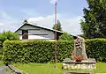 World War I memorial
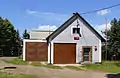 Fire station
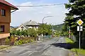 Main street
References
- ↑ "Population of Municipalities – 1 January 2023". Czech Statistical Office. 2023-05-23.
- ↑ "Historie obce Chaloupky" (in Czech). Obec Chaloupky. Retrieved 2022-03-24.
- ↑ "Zřícenina hradu Valdek" (in Czech). CzechTourism. Retrieved 2022-05-16.
External links
Wikimedia Commons has media related to Chaloupky.
This article is issued from Wikipedia. The text is licensed under Creative Commons - Attribution - Sharealike. Additional terms may apply for the media files.