Champagnac-la-Noaille | |
|---|---|
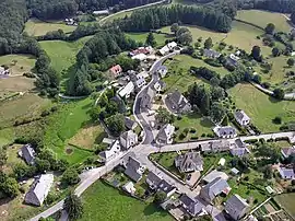 An aerial view of Champagnac-la-Noaille | |
.svg.png.webp) Coat of arms | |
Location of Champagnac-la-Noaille | |
 Champagnac-la-Noaille  Champagnac-la-Noaille | |
| Coordinates: 45°18′28″N 2°01′00″E / 45.3077°N 2.0167°E | |
| Country | France |
| Region | Nouvelle-Aquitaine |
| Department | Corrèze |
| Arrondissement | Ussel |
| Canton | Égletons |
| Government | |
| • Mayor (2020–2026) | Jean-Pierre Valadour[1] |
| Area 1 | 25.47 km2 (9.83 sq mi) |
| Population | 223 |
| • Density | 8.8/km2 (23/sq mi) |
| Demonym | Champagnacois |
| Time zone | UTC+01:00 (CET) |
| • Summer (DST) | UTC+02:00 (CEST) |
| INSEE/Postal code | 19039 /19320 |
| Elevation | 492–630 m (1,614–2,067 ft) (avg. 560 m or 1,840 ft) |
| 1 French Land Register data, which excludes lakes, ponds, glaciers > 1 km2 (0.386 sq mi or 247 acres) and river estuaries. | |
Champagnac-la-Noaille (French pronunciation: [ʃɑ̃paɲak la nɔaj]; Occitan: Champanhac la Noalha) is a commune in the Corrèze department in central France.[3]
Population
| Year | Pop. | ±% p.a. |
|---|---|---|
| 1968 | 315 | — |
| 1975 | 293 | −1.03% |
| 1982 | 258 | −1.80% |
| 1990 | 221 | −1.92% |
| 1999 | 190 | −1.67% |
| 2009 | 225 | +1.71% |
| 2014 | 239 | +1.21% |
| 2020 | 226 | −0.93% |
| Source: INSEE[4] | ||
See also
References
- ↑ "Répertoire national des élus: les maires". data.gouv.fr, Plateforme ouverte des données publiques françaises (in French). 2 December 2020.
- ↑ "Populations légales 2021". The National Institute of Statistics and Economic Studies. 28 December 2023.
- ↑ Commune de Champagnac-la-Noaille (19039), INSEE
- ↑ Population en historique depuis 1968, INSEE
External links
Wikimedia Commons has media related to Champagnac-la-Noaille.
This article is issued from Wikipedia. The text is licensed under Creative Commons - Attribution - Sharealike. Additional terms may apply for the media files.