Cherré | |
|---|---|
Part of Cherré-Au | |
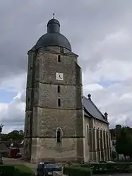 The church of Saint Pierre and Saint Paul | |
Location of Cherré | |
 Cherré  Cherré | |
| Coordinates: 48°10′20″N 0°39′25″E / 48.1722°N 0.6569°E | |
| Country | France |
| Region | Pays de la Loire |
| Department | Sarthe |
| Arrondissement | Mamers |
| Canton | La Ferté-Bernard |
| Commune | Cherré-Au |
| Area 1 | 18.73 km2 (7.23 sq mi) |
| Population (2019)[1] | 1,784 |
| • Density | 95/km2 (250/sq mi) |
| Demonym(s) | Cherréen, Cherréenne |
| Time zone | UTC+01:00 (CET) |
| • Summer (DST) | UTC+02:00 (CEST) |
| Postal code | 72400 |
| Elevation | 78–131 m (256–430 ft) |
| 1 French Land Register data, which excludes lakes, ponds, glaciers > 1 km2 (0.386 sq mi or 247 acres) and river estuaries. | |
Cherré (French pronunciation: [ʃɛʁe] ⓘ) is a former commune in the Sarthe department in the Pays de la Loire region in north-western France. On 1 January 2019, it was merged into the new commune Cherré-Au.[2]
See also
References
- ↑ Téléchargement du fichier d'ensemble des populations légales en 2019, INSEE
- ↑ Arrêté préfectoral 13 September 2018 (in French)
Wikimedia Commons has media related to Cherré (Sarthe).
This article is issued from Wikipedia. The text is licensed under Creative Commons - Attribution - Sharealike. Additional terms may apply for the media files.