Clonaghadoo | |
|---|---|
Village | |
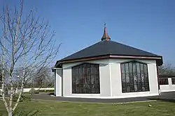 Clonaghadoo Church | |
| Country | Ireland |
| Province | Leinster |
| County | County Laois |
| Time zone | UTC+0 (WET) |
| • Summer (DST) | IST (WEST) |
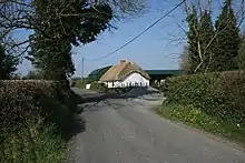
The road to Clonaghadoo
Clonaghadoo is a village in County Laois, Ireland, located 6 km (3.7 mi) north of Mountmellick just off the N80 national secondary road. The Slieve Bloom Mountains lie southwest of the village. The village is part of the Roman Catholic parish Mountmellick.
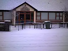
St Marys National School Clonaghadoo
Amenities
There is a Catholic church, school and a community hall. The hall was originally a Clonaghadoo National School, opened in 1912. The name Clonaghadoo comes from Cluanacha Dubha, or the Black Meadows.[1]
In the grounds of the church there is a labyrinth of low hedges and gravel paths.[2]
See also
External links
- ↑ "logainm.ie - Bunachar Logainmneacha na hÉireann - Placenames Database of Ireland". Archived from the original on 5 September 2012.
- ↑ Clonaghadoo Labyrinth
53°10′16″N 7°22′19″W / 53.1711°N 7.3719°W
Places in County Laois | ||
|---|---|---|
| Towns |  | |
| Villages and Townlands |
| |
| Landforms | ||
| ||
This article is issued from Wikipedia. The text is licensed under Creative Commons - Attribution - Sharealike. Additional terms may apply for the media files.