Cobar Airport | |||||||||||||||
|---|---|---|---|---|---|---|---|---|---|---|---|---|---|---|---|
 Aerial image, 6 March 2009 | |||||||||||||||
| Summary | |||||||||||||||
| Airport type | Public | ||||||||||||||
| Operator | Cobar Shire Council | ||||||||||||||
| Serves | Cobar, New South Wales, Australia | ||||||||||||||
| Elevation AMSL | 724 ft / 221 m | ||||||||||||||
| Coordinates | 31°32′18″S 145°47′36″E / 31.53833°S 145.79333°E | ||||||||||||||
| Map | |||||||||||||||
 YCBA Location in New South Wales | |||||||||||||||
| Runways | |||||||||||||||
| |||||||||||||||
Sources: Enroute Supplement Australia from Airservices Australia[1] | |||||||||||||||
Cobar Airport (IATA: CAZ, ICAO: YCBA) is an airport located 3 nautical miles (5.6 km; 3.5 mi) southwest[1] of Cobar, a town in the Australian state of New South Wales.
Facilities
The airport is 724 ft (221 m) above mean sea level.[1] It has two runways: 05/23 with an asphalt surface measuring 1,519 by 30 metres (4,984 ft × 98 ft) and 17/35 with a clay surface measuring 1,221 by 30 metres (4,006 ft × 98 ft).[1]
Airlines and destinations
| Airlines | Destinations |
|---|---|
| FlyPelican | Sydney |
Accidents and incidents
- On 23 April 2023, Pel-Air Flight 9982 diverted to Cobar after the crew received a cargo area smoke warning and shortly after, observed smoke in the cockpit. The SAAB 340A was operating a cargo flight from Wagga Wagga to Charleville.[2] On landing, the aircraft was met by local fire fighters who entered the cabin to investigate the source, which was found to be electrical and extinguished. The aircraft's floor was significantly damaged by the fire.[3]
See also
Gallery
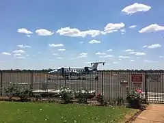
 Beechcraft 1900D of Air Link parked on the apron at Cobar airport
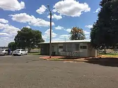
 Cobar airport terminal building
References
- 1 2 3 4 YCBA – COBAR (PDF). AIP En Route Supplement from Airservices Australia, effective 2023-11-30
- ↑ Simon Hradecky (24 April 2023). "Accident: Pel SF34 near Cobar on Apr 23rd 2023, fire on board". The Aviation Herald.
- ↑ David Kaminski-Morrow (24 April 2023). "In-flight fire damages Pel-Air Saab 340 freighter". FlightGlobal.
External links
This article is issued from Wikipedia. The text is licensed under Creative Commons - Attribution - Sharealike. Additional terms may apply for the media files.