Columbus–Auburn–Opelika, GA–AL Combined Statistical Area | |
|---|---|
 Skyline of Columbus, Georgia | |
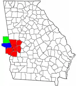 Location of the Columbus, Georgia–Auburn, Alabama CSA and its counties: Columbus, Georgia Metropolitan Statistical Area Auburn-Opelika, Alabama Metropolitan Statistical Area Valley, Alabama Micropolitan Statistical Area, (Not included as of the 2020 Census) | |
| Country | United States |
| States | Georgia Alabama |
| Largest city | Columbus, Georgia |
| Population (2016 est.) | |
| • CSA | 501,961 (89th) |
| Area code(s) | 706, 762, 334 |
The Columbus–Auburn–Opelika, GA–AL Combined Statistical Area[1] is a trading and marketing area made up of six counties in Georgia and two in Alabama. The statistical area includes two metropolitan areas: the Columbus metropolitan area and the Auburn–Opelika metropolitan area. As of 2021, the CSA had a population of 503,709.[2][3]
The Combined Statistical Area consists of the:
- Columbus metropolitan area, population 326,491.
- Auburn–Opelika metropolitan area, population 177,218.
Counties
In Georgia
- Chattahoochee County pop. 9,565
- Harris County pop. 34,668
- Marion County pop. 7,498
- Muscogee County pop. 206,922
- Stewart County pop. 5,314
- Talbot County pop. 5,733
In Alabama
- Lee County pop. 163,461
- Russell County pop. 57,938
Communities
The communities (both incorporated and unincorporated) in the combined statistical area are as follows. Bold name indicates the principal cities in the CSA:
- In Alabama
- Auburn pop. 76,143[4]
- Beauregard pop. 5,234
- Bee Hive pop. unknown
- Beulah pop. 6,173
- Fort Mitchell pop. 3,11
- Glenville pop. unknown
- Gold Hill pop. unknown
- Holy Trinity pop. unknown
- Hurtsboro pop. 592
- Ladonia pop. 1,943
- Loachapoka pop. 165
- Marvyn pop. 5,235
- Notasulga pop. 916
- Opelika pop. 26,477
- Phenix City pop. 38,816
- Roxana pop. 1,942
- Salem pop. 6,428
- Seale pop. 2,382
- Smiths Station pop. 21,756
- The Bottle pop. unknown
- Waverly pop. 180
- In Georgia
- Buena Vista pop. 1,664
- Cataula pop. 3,784
- Columbus pop. 206,922
- Cusseta pop. 1,196
- Ellerslie pop. 3,292
- Fort Benning South pop. 11,737
- Hamilton pop. 307
- Hopewell pop. unknown
- Juniper pop. 2,830
- Mountain Hill pop. unknown
- Mulberry Grove pop. unknown
- Pine Mountain pop. 1,141
- Rehobeth pop. unknown
- Ridgeway pop. unknown
- Shiloh pop. 423
- Waverly Hall pop. 790
- West Point pop. 3,487
- Whitesville pop. 150
Education institutes
Higher education

Public
- Auburn University
- Columbus State University
- Columbus Technical College
- Chattahoochee Valley Community College (Phenix City)
- Georgia Military College - main campus in Milledgeville, Georgia
- Southern Union State Community College (Opelika)
- Troy University - campuses in Columbus, Fort Benning, and Phenix City, main campus in Troy, Alabama
Private, for profit
- Christian Life School of Theology (Columbus)
- Miller-Motte Technical College - main campus in Wilmington, North Carolina
- Rivertown School of Beauty (Columbus)
- Southeastern Beauty School (Columbus)
- Strayer University - main campus in Baltimore, Maryland
Primary and secondary education
Transportation
Airports
Below is a list of the airports in the greater area, followed by their number of enplanements (commercial passenger boardings) that occurred at the airport in calendar year 2008.
Public
- Auburn-Opelika Robert G. Pitts Airport (IATA: AUO, ICAO: KAUO, FAA LID: AUO), 68
- Columbus Airport (IATA: CSG, ICAO: KCSG, FAA LID: CSG), 51,288
Private
- Harris County Airport (IATA: PIM, ICAO: KPIM, FAA LID: PIM), 116
- Jones Light Aviation Airport (FAA LID: AL56), n/a
- Lawson Army Airfield (IATA: LSF, ICAO: KLSF, FAA LID: LSF), 13,702
- Marion County Airport (FAA LID: 82A), n/a
Interstates
Principal Highways
State Highways
 Alabama State Route 14
 Alabama State Route 26
 Alabama State Route 51
 Alabama State Route 147
 Alabama State Route 165
 Alabama State Route 169
 Alabama State Route 267
 Georgia State Route 18
 Georgia State Route 22
 Georgia State Route 26
 Georgia State Route 27
 Georgia State Route 30
 Georgia State Route 36
 Georgia State Route 39
 Georgia State Route 41
 Georgia State Route 85
 Georgia State Route 90
 Georgia State Route 96
 Georgia State Route 103
 Georgia State Route 116
 Georgia State Route 127
 Georgia State Route 137
 Georgia State Route 190
 Georgia State Route 208
 Georgia State Route 219
 Georgia State Route 240
 Georgia State Route 315
 Georgia State Route 352
 Georgia State Route 354
 Georgia State Route 355
 Georgia State Route 520
 Georgia State Route 540
Sports
Shopping
Below are some notable shopping centers in the area:
- Columbus Park Crossing (Columbus)
- Peachtree Mall (Columbus)
- The Landings (Columbus)
- The Shoppes at Bradley Park (Columbus)
- TigerTown (Opelika)
- Auburn Mall (Auburn)
Notable people
References
- ↑ "Table 1. Annual Estimates of the Population of Metropolitan and Micropolitan Statistical Areas: April 1, 2000 to July 1, 2009 (CBSA-EST2009-01)". 2009 Population Estimates. United States Census Bureau, Population Division. 2010-03-23. Archived from the original (CSV) on 2010-06-15. Retrieved 2010-03-24.
- ↑ "Results". censusreporter.org.
- ↑ "Census profile: Columbus-Auburn-Opelika, GA-AL CSA".
- ↑ "QuickFacts Auburn city, Alabama". Population, Census, April 1, 2020. U.S. Census Bureau. August 14, 2020. Retrieved August 14, 2020.
| Central cities/Largest cities |  Location of the Columbus, Georgia-Auburn, Alabama CSA and its counties:
Columbus, Georgia Metropolitan Statistical Area
Auburn, Alabama Metropolitan Statistical Area
Tuskegee, Alabama Micropolitan Statistical Area (defunct) | |
|---|---|---|
| Cities in Georgia | ||
| Cities in Alabama | ||
| Counties in Georgia | ||
| Counties in Alabama | ||