Courcy | |
|---|---|
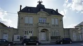 The town hall in Courcy | |
Location of Courcy | |
 Courcy  Courcy | |
| Coordinates: 49°19′26″N 4°00′12″E / 49.3239°N 4.0033°E | |
| Country | France |
| Region | Grand Est |
| Department | Marne |
| Arrondissement | Reims |
| Canton | Bourgogne-Fresne |
| Intercommunality | CU Grand Reims |
| Government | |
| • Mayor (2020–2026) | Martine Jolly[1] |
| Area 1 | 15.5 km2 (6.0 sq mi) |
| Population | 1,247 |
| • Density | 80/km2 (210/sq mi) |
| Time zone | UTC+01:00 (CET) |
| • Summer (DST) | UTC+02:00 (CEST) |
| INSEE/Postal code | 51183 /51220 |
| Elevation | 75–161 m (246–528 ft) (avg. 78 m or 256 ft) |
| 1 French Land Register data, which excludes lakes, ponds, glaciers > 1 km2 (0.386 sq mi or 247 acres) and river estuaries. | |
Courcy (French pronunciation: [kuʁsi] ⓘ) is a commune in the Marne department in north-eastern France. Courcy-Brimont station has rail connections to Reims and Laon.
History
Courcy was a contested village during the First World War. During the Second Battle of the Aisne the Russian Expeditionary Force in France captured the village on 16 April 1917.
 Generals Nikolai Aleksandrovich Lokhvitsky and Fyodor Fyodorovich Palitzin inspecting the Russian soldiers at Courcy, 13 May 1917
See also
References
- ↑ "Répertoire national des élus: les maires" (in French). data.gouv.fr, Plateforme ouverte des données publiques françaises. 13 September 2022.
- ↑ "Populations légales 2021". The National Institute of Statistics and Economic Studies. 28 December 2023.
Wikimedia Commons has media related to Courcy (Marne).
This article is issued from Wikipedia. The text is licensed under Creative Commons - Attribution - Sharealike. Additional terms may apply for the media files.