Crenshaw, Pennsylvania | |
|---|---|
 | |
 Crenshaw  Crenshaw | |
| Coordinates: 41°14′55″N 78°45′15″W / 41.24861°N 78.75417°W | |
| Country | United States |
| State | Pennsylvania |
| County | Jefferson |
| Township | Snyder |
| Area | |
| • Total | 1.12 sq mi (2.89 km2) |
| • Land | 1.09 sq mi (2.84 km2) |
| • Water | 0.02 sq mi (0.05 km2) |
| Elevation | 1,480 ft (450 m) |
| Population | |
| • Total | 423 |
| • Density | 386.30/sq mi (149.11/km2) |
| Time zone | UTC-5 (Eastern (EST)) |
| • Summer (DST) | UTC-4 (EDT) |
| FIPS code | 42-17040 |
| GNIS feature ID | 2630002 |
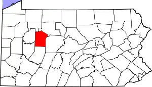
Crenshaw is an unincorporated community and census-designated place in Snyder Township, Jefferson County in the U.S. state of Pennsylvania. It is approximately 2 miles (3 km) east of the borough of Brockway on U.S. Route 219. As of the 2010 census, the population was 468 residents.[3]
Demographics
| Census | Pop. | Note | %± |
|---|---|---|---|
| 2020 | 423 | — | |
| U.S. Decennial Census[4][2] | |||
History
The railroad was extended to Crenshaw around 1882.[5] A post office was established at Crenshaw in 1886, and remained in operation until 1967.[6]
References
- ↑ "ArcGIS REST Services Directory". United States Census Bureau. Retrieved October 12, 2022.
- 1 2 "Census Population API". United States Census Bureau. Retrieved October 12, 2022.
- ↑ "Geographic Identifiers: 2010 Census Summary File 1 (G001): Crenshaw CDP, Pennsylvania". American Factfinder. U.S. Census Bureau. Archived from the original on February 13, 2020. Retrieved November 8, 2018.
- ↑ "Census of Population and Housing". Census.gov. Retrieved June 4, 2016.
- ↑ McKnight, William James (1917). Historical. J.H. Beers. p. 105.
- ↑ "Jefferson County". Jim Forte Postal History. Archived from the original on March 4, 2016. Retrieved December 2, 2015.
External links
This article is issued from Wikipedia. The text is licensed under Creative Commons - Attribution - Sharealike. Additional terms may apply for the media files.
